Area Overview for NG1 7JA
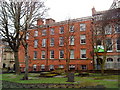
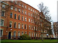
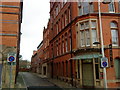
Photos of NG1 7JA


Area Information
Living in NG1 7JA means being part of a small, tightly knit residential cluster in Nottingham, England. With a population of just 1,369 people, this area has a distinct character shaped by its compact size and proximity to the city’s core. The area is known for its accessibility, with multiple tram stops, railway stations, and retail hubs within easy reach. Daily life here is defined by convenience and connectivity, offering residents easy access to both urban amenities and transport options. The community is young, with the majority of residents aged between 15 and 29 years, creating a dynamic and energetic atmosphere. While the area is small, it provides a mix of practical living with access to essential services. NG1 7JA is not a sprawling suburb but a focused postcode that reflects the rhythm of city living, blending residential comfort with the vibrancy of Nottingham’s urban fabric.
- Area Type
- Postcode
- Area Size
- Not available
- Population
- 1369
- Population Density
- 2415 people/km²
The property market in NG1 7JA is characterised by a low home ownership rate of just 13%, suggesting that the area is not primarily owner-occupied. Instead, it is more likely to be a rental market, with most properties being flats. This reflects the area’s appeal to younger residents, possibly students or those in temporary employment. The compact nature of the postcode means that the housing stock is limited in scale, and the availability of flats suggests a focus on smaller, more manageable living spaces. For buyers considering the area, the small size of NG1 7JA means that the immediate surroundings may offer more options. However, the low home ownership rate indicates that the market may be more competitive for those seeking to buy rather than rent. The limited housing stock also means that buyers should be prepared to act quickly if a suitable property becomes available.
House Prices in NG1 7JA
No properties found in this postcode.
Energy Efficiency in NG1 7JA
Residents of NG1 7JA have access to a variety of nearby amenities, including five retail stores such as Tesco Nottingham, Co-op Nottingham, and M&S Nottingham. These shops provide essential services and convenience for daily living. The area also benefits from multiple tram stops and railway stations, making it easy to travel to other parts of the city or beyond. While the data does not mention parks or leisure facilities specifically, the proximity to urban centres suggests that residents can access a range of recreational and leisure options nearby. The presence of retail and transport hubs contributes to a practical and convenient lifestyle, supporting both daily errands and social activities. The character of the area is shaped by its accessibility and the availability of essential services, making it suitable for those who value convenience and connectivity in their daily lives.
Amenities
Schools
The only school listed near NG1 7JA is St George’s Pupil Referral Unit, which is categorised as an "other" type of educational institution. This suggests that the area does not have traditional primary or secondary schools within its immediate vicinity. For families with children, this means that they would need to look beyond NG1 7JA for mainstream schooling options. The absence of conventional schools in the area may be a concern for parents seeking a comprehensive educational environment for their children. It is important to note that the data does not provide any Ofsted ratings or specific details about the school’s performance. Families considering NG1 7JA should therefore investigate the availability and quality of local schools in the surrounding areas to ensure that their children’s educational needs are met.
| Rank | School | Type | Entry gender | Ages |
|---|
Explore more schools in this area
Go to Schools tabDemographics
The demographic profile of NG1 7JA is clearly defined by its young population, with the most common age group being young adults aged 15 to 29 years. This reflects a community that is likely to be student-focused or early in their careers. The area has a home ownership rate of just 13%, indicating that the majority of residents are likely to be renting. Most properties in the area are flats, which aligns with the younger demographic and the compact nature of the postcode. The predominant ethnic group is White, which is consistent with broader trends in Nottingham. The low home ownership rate suggests a transient population, with many residents potentially moving in for short-term reasons such as education or employment. This has implications for community stability and long-term investment in the area.
Household Size
Accommodation Type
Tenure
Ethnic Group
Religion
Household Composition
Age
Household Deprivation
NS-SEC
Explore more demographic insights in this area
Go to Demographics tabPlanning
Planning Constraints
- Flood RiskPremium
- Ramsar Wetland SitesPremium
- Area of Outstanding Natural BeautyPremium
- Protected Nature ReservePremium
- Protected WoodlandPremium