Area Overview for NG1 2NN
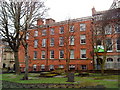
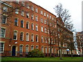
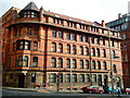
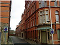
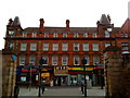
Photos of NG1 2NN


Area Information
Living in NG1 2NN offers a compact, residential experience with a population of 2746 people. This postcode area is a small cluster of homes, primarily occupied by young adults aged 15 to 29. The community is relatively tight-knit, with a distinct character shaped by its size and local amenities. You’ll find yourself close to a variety of services, including retail outlets, public transport hubs, and nearby schools. The area is well-connected, with tram stops and railway stations within easy reach. While the population is small, the density of amenities and transport options means daily life is convenient. The area does not have any major natural or environmental constraints, which makes it a practical choice for those looking for a manageable, accessible place to live. The broadband and mobile coverage are good, supporting both remote work and everyday internet use. NG1 2NN is a place where practicality meets proximity, offering a straightforward lifestyle for those who value accessibility and simplicity.
- Area Type
- Postcode
- Area Size
- Not available
- Population
- 2746
- Population Density
- 5867 people/km²
The property market in NG1 2NN is characterised by a high proportion of rental properties, with only 20% of homes being owner-occupied. This suggests that the area is more of a rental market than an owner-occupied one, which could be due to the age profile of the residents and the type of housing available. The accommodation type is predominantly flats, which are typically more suited to younger, transient populations. This makes the area more appealing to students, young professionals, or those looking for short-term housing. For buyers considering the area, it may be challenging to find owner-occupied properties, and the market is likely more competitive for those seeking to buy. The small size of the postcode area means that property options are limited, and the immediate surroundings are likely to have similar characteristics. This suggests that buyers should consider a broader area if they are looking for a wider selection of homes.
House Prices in NG1 2NN
No properties found in this postcode.
Energy Efficiency in NG1 2NN
Residents of NG1 2NN have access to a variety of amenities within practical reach, enhancing their daily lifestyle. The area is close to several retail outlets, including Sainsburys Nottingham, M&S Nottingham, and Tesco Maid Marian, providing convenient shopping options. Public transport is readily available, with tram stops such as Old Market Square Tram Stop and railway stations like Nottingham Railway Station, making it easy to travel around the city. The presence of these transport links also supports a connected lifestyle, allowing residents to access cultural and leisure activities in the surrounding areas. While the data does not provide information on parks or leisure facilities, the proximity to a range of retail and transport options suggests that the area is well-suited for those who value convenience and accessibility. The compact nature of NG1 2NN means that daily life is efficient, with amenities and services within easy reach.
Amenities
Schools
The schools near NG1 2NN include Arkwright Primary and Nursery School, a primary school with no Ofsted rating listed, and Greenfields Community School, also a primary school with a 'good' Ofsted rating. There is also Rise Learning Zone, an independent school. This mix of school types offers families a range of options, from state-funded primary education to private schooling. The presence of a school with a 'good' rating indicates that at least one local school provides a quality education. For families with young children, the availability of both state and independent schools can be a significant factor in choosing where to live. The proximity of these schools to NG1 2NN makes it an attractive option for parents seeking a convenient and varied educational environment for their children.
| Rank | School | Type | Entry gender | Ages |
|---|
Explore more schools in this area
Go to Schools tabDemographics
The community in NG1 2NN is predominantly young, with a median age of 22 and the most common age range being 15 to 29 years. This suggests a population that is largely students or young professionals. Home ownership in the area is relatively low, with only 20% of residents owning their homes. The accommodation type is primarily flats, which aligns with the younger demographic and the compact nature of the area. The predominant ethnic group is White, which reflects the broader demographic trends in the region. While the data does not provide specific information on deprivation, the young age profile and high proportion of renters suggest a community that may be more transient. This could influence the social dynamics and the character of the area, with a focus on shared spaces and communal living. The demographic profile indicates a place that is evolving, shaped by the needs and preferences of its younger residents.
Household Size
Accommodation Type
Tenure
Ethnic Group
Religion
Household Composition
Age
Household Deprivation
NS-SEC
Explore more demographic insights in this area
Go to Demographics tabPlanning
Planning Constraints
- Flood RiskPremium
- Ramsar Wetland SitesPremium
- Area of Outstanding Natural BeautyPremium
- Protected Nature ReservePremium
- Protected WoodlandPremium