Area Overview for NG1 2GX
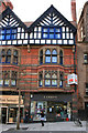
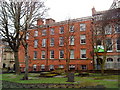
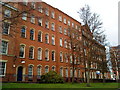
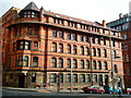
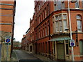
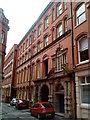
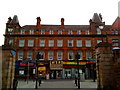
Photos of NG1 2GX


Area Information
Living in NG1 2GX offers a compact, residential experience in a small cluster of homes in Nottingham, England. With a population of 2746, this area is a tight-knit community where daily life is shaped by proximity to local amenities and transport links. The postcode covers a focused residential cluster, making it easy to navigate and feel connected to nearby services. The area is well-served by retail outlets, public transport, and educational institutions, creating a balanced environment for those who prefer a mix of urban convenience and residential comfort. While the population is relatively small, the variety of nearby facilities ensures that residents have access to essential services without needing to travel far. NG1 2GX is a place where practicality meets accessibility, offering a straightforward lifestyle for those seeking a manageable, connected living space in a well-established part of Nottingham.
- Area Type
- Postcode
- Area Size
- Not available
- Population
- 2746
- Population Density
- 5867 people/km²
The property market in NG1 2GX is likely to reflect the characteristics of a small, residential postcode area. While specific data on home ownership percentages is not provided, the presence of multiple schools and amenities suggests a mix of owner-occupied and rental properties. The area’s compact size means that housing stock is likely to be concentrated in a limited number of properties, possibly including a range of accommodation types such as terraced houses, flats, and semi-detached homes. The small population and proximity to transport links may make this area appealing to buyers seeking a manageable, accessible location. However, the lack of detailed data on property types and ownership levels means that potential buyers should consider the broader Nottingham market when evaluating opportunities in NG1 2GX. The area’s small footprint may also mean that property values are influenced by nearby developments and local demand.
House Prices in NG1 2GX
No properties found in this postcode.
Energy Efficiency in NG1 2GX
Residents of NG1 2GX have access to a range of nearby amenities that support a practical and varied lifestyle. The area is within reach of major retail outlets such as M&S Nottingham, Tesco Fletcher Gate, and Sainsburys Nottingham, ensuring that everyday shopping needs are easily met. The presence of multiple tram stops and railway stations provides convenient access to the city centre and beyond, supporting both commuting and leisure activities. The proximity to Nottingham Airport also makes travel to other regions or abroad more accessible. This mix of retail, transport, and travel options contributes to a dynamic, connected lifestyle. The availability of these amenities enhances the convenience of daily life, allowing residents to enjoy a balance between local convenience and broader opportunities.
Amenities
Schools
The schools near NG1 2GX include Arkwright Primary and Nursery School, a primary school, and Greenfields Community School, which also serves primary students and holds a ‘good’ Ofsted rating. Rise Learning Zone is an independent school in the vicinity. This mix of state and independent education options provides families with choices that cater to different preferences and needs. The presence of a school with a ‘good’ rating is a positive sign for parents seeking quality education for their children. The variety of school types ensures that families can select between free, state-funded education and the more specialised offerings of independent schools. This diversity supports a range of educational philosophies and financial considerations, making NG1 2GX a suitable area for families with varying priorities when it comes to schooling.
| Rank | School | Type | Entry gender | Ages |
|---|
Explore more schools in this area
Go to Schools tabDemographics
The community in NG1 2GX consists of 2746 residents, though specific data on age profile, household types, and home ownership levels is not provided. The area is likely to reflect broader Nottingham trends, with a mix of household compositions and housing types. While exact figures on deprivation or diversity are not available, the presence of multiple schools and amenities suggests a varied population. The small size of the area means that community dynamics are likely to be close-knit, with a sense of familiarity among residents. The absence of detailed demographic data means that assumptions about the area’s social fabric must be made cautiously. However, the availability of local schools and transport options points to a community that supports families and commuters alike, offering a practical base for a range of lifestyles.
Household Size
Accommodation Type
Tenure
Ethnic Group
Religion
Household Composition
Age
Household Deprivation
NS-SEC
Explore more demographic insights in this area
Go to Demographics tabPlanning
Planning Constraints
- Flood RiskPremium
- Ramsar Wetland SitesPremium
- Area of Outstanding Natural BeautyPremium
- Protected Nature ReservePremium
- Protected WoodlandPremium