Area Overview for Netherseal
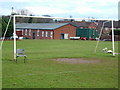
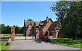
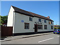
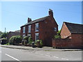
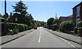
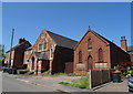
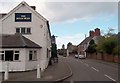
Photos of Netherseal

Area Information
Netherseal is a compact built-up area in England, covering 27.5 hectares. Its population is predominantly older, with a median age of 70, suggesting a community shaped by long-term residents. The area’s character is defined by its stability, with 75% of homes owner-occupied, reflecting a settled demographic. Daily life here is likely quiet and routine-driven, with local amenities and schools forming the backbone of community interaction. While the area is small, it offers practical access to nearby retail outlets and essential services. For buyers, Netherseal presents a niche opportunity: a low-crime environment with a mature population, though its appeal may depend on whether the pace of life aligns with personal preferences. The absence of major transport hubs or cultural attractions means it caters to those prioritising safety, simplicity, and proximity to basic amenities over urban vibrancy.
- Area Type
- Built Up Area 250
- Area Size
- 27.5 hectares
- Population
- Not available
- Population Density
- Not available
Residents of Netherseal have access to five retail outlets within practical reach, including notable Co-ops in Overseal, Moira, and Measham. These stores provide essential shopping options, from groceries to everyday necessities, reducing the need for long commutes. While the data does not mention dining, parks, or leisure facilities, the presence of multiple retail points suggests a basic level of convenience for daily life. The area’s lifestyle appears to prioritise practicality over luxury, with amenities focused on meeting fundamental needs rather than offering expansive recreational opportunities. For those valuing simplicity and proximity to essential services, Netherseal’s amenities align with a low-maintenance, community-oriented way of living.
Amenities
Schools
The nearest school to Netherseal is Netherseal St Peter’s CofE (C) Primary School, which serves the local community with a ‘good’ Ofsted rating. This primary school is the only educational institution explicitly mentioned in the data, indicating that families with young children may need to look beyond the immediate area for secondary education. The presence of a well-rated primary school is a positive factor for families, though the absence of secondary schools nearby could pose logistical challenges. Parents should investigate further to understand the full range of educational options available, including commuting distances and alternative provisions.
| Rank | School | Type | Entry gender | Ages |
|---|
Explore more schools in this area
Go to Schools tabDemographics
Netherseal’s population is predominantly aged 70, with the most common age range encompassing the total population. This suggests a community where older residents form a significant proportion, potentially influencing local services and social dynamics. Home ownership is high at 75%, indicating a stable housing market with fewer rental properties. The data does not specify household composition or accommodation types, but the overall figures imply a homogeneous demographic profile. Deprivation levels are not quantified here, but the low crime risk and high home ownership suggest a relatively secure, low-stress environment. However, the lack of diversity in age and household structure may limit the range of social interactions and community activities available to residents.
Household Size
Accommodation Type
Tenure
Ethnic Group
Religion
Household Composition
Age
Household Deprivation
NS-SEC
Explore more demographic insights in this area
Go to Demographics tabPlanning
Planning Constraints
- Crime RiskPremium