Area Overview for Meadows Ward
Photos of Meadows Ward


Area Information
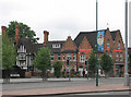
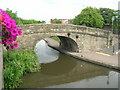
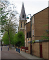
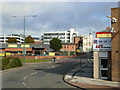
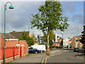
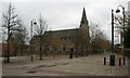
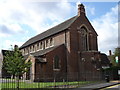
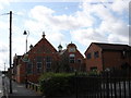
Living in Meadows Ward offers a distinct experience within Nottingham, situated south of the city centre and adjacent to the River Trent. This district spans 3.2 km² and hosts a population of 1,785 residents within the East Midlands region. The area encompasses former wetlands that now form a developed urban residential zone. Its history dates back to the mid-1800s when it transitioned from a floodplain drained for housing and factories to a structured community. You will find the area bounded closely by specific coordinates, linking it historically to the former Bridge Ward and including the neighbourhood of Dunkirk. Daily life here revolves around a mix of surviving terraced streets and modern council housing blocks. Notable landmarks include the Victoria Embankment, a substantial Victorian flood defence structure with a promenade, and the New Meadows recreation ground. The Memorial Gardens, established with land donated by Jesse Boot in 1920, provide green space with Art Deco bandstands and sports pavilions. St Saviour's Church, built in 1864, remains one of the few original structures surviving the redevelopment of the seventies. While the area has undergone significant changes, including the removal of the Great Central Railway viaduct in 1975, these historical layers define the current character. The layout includes planned segregated paths and underpasses intended to separate pedestrian and traffic flow. Despite past challenges with anti-social behaviour, a 2009 Neighbourhood Plan aimed to restore traditional street layouts to improve the environment. You are settling into a district where industrial history meets modern residential design, defined by its river location and layered past.
- Area Type
- District Borough Unitary Ward
- Area Size
- 3.2 km²
- Population
- 1785
- Population Density
- 551 people/km²
Demographics
The community within Meadows Ward presents a specific demographic profile, most notably indicated by a median age of 70 years. This figure suggests a settlement where older residents form a significant portion of the population. The most common age range is recorded generically as 'Age: Total', indicating the data aggregates across all cohorts without isolating specific youthful or middle-aged brackets. This demographic skew implies a neighbourhood often characterised by established households rather than young families or students. Regarding home ownership, only 36% of residents own their properties outright. Consequently, the majority of households likely reside in the private rental sector or are owner-occupiers who have not yet sold. The available data covers total household composition and total accommodation types without breaking down specific unit styles for this section. While specific information on the predominant ethnic group and religious background is not detailed in the current records, the narrow ownership rate points toward areas where renting may be more prevalent than buyer ownership. The high median age correlates with the presence of larger housing stock and the historic development patterns of the mid-nineteenth and early twentieth centuries. You should expect a quieter residential environment shaped by these longer-term residents rather than a fast-paced hub of young professionals. The social fabric is rooted in this older population baseline, which influences local service demand and the general pace of life on the streets.
Household Size
Accommodation Type
Tenure
Ethnic Group
Religion
Household Composition
Age
Household Deprivation
NS-SEC
Explore more demographic insights in this area
Go to Demographics tabPlanning
Planning Constraints
- Flood RiskPremium
- Ramsar Wetland SitesPremium
- Area of Outstanding Natural BeautyPremium
- Protected Nature ReservePremium
- Protected WoodlandPremium
- Crime RiskPremium