Area Overview for Lubenham
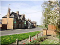
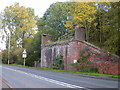
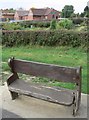
Photos of Lubenham


Area Information
Lubenham stands as a small built-up area within England, covering 31.0 hectares. This compact footprint defines a neighbourhood where the scale of development remains modest. Living in Lubenham means navigating a specific, contained environment rather than a sprawling suburban expansion. The area currently functions as a distinct community hub for local residents. Its size suggests a low-density setting where distances between homes likely keep daily journeys relatively short. You will find yourself in a location characterized by established ground rather than new construction zones. The designation of Lubenham as a built-up area confirms its status as a recognisable settlement with defined boundaries. This specific geography supports a lifestyle that relies on local amenities for immediate needs. The character of the area reflects its established nature, offering a setting that has developed over time rather than being part of recent large-scale projects.
- Area Type
- Built Up Area 250
- Area Size
- 31.0 hectares
- Population
- Not available
- Population Density
- Not available
Daily life in Lubenham is supported by a focused selection of amenities within practical reach. Retail options include one Spar store, a Co-op Leicester, and a Co-op Petrol station. These three retail outlets provide essential shopping needs without requiring long commutes to larger cities. The presence of a petrol station indicates that vehicle access is key to mobility in this 31-hectare area. Transport links include one railway station nearby, identified as Market Harborough Railway Station. This rail connection offers a direct link to broader regional networks for those wishing to travel beyond their local district. Leisure and park options are not explicitly detailed in the provided data, so residents likely rely on the nearby stations and shops for their main travel and commercial activities. The single bookstore mention in the retail category suggests a modest cultural footprint. For someone living in Lubenham, the layout demands a car for most trips that do not strictly require walking distance. The amenities listed ensure that basic necessities, fuel, and regional rail access are always within easy reach.
Amenities
Schools
The educational landscape nearest to Lubenham centres on a single primary option. Lubenham All Saints Church of England Primary School stands as the main facility for younger students in the vicinity. This school holds a good Ofsted rating, confirming that it meets solid educational standards according to government inspectors. It serves as a quality local option for families residing in or near the built-up area. The absence of secondary schools in the immediate data list implies that pupils in Lubenham typically travel to larger towns for high-level education. For parents deciding on schools near Lubenham, this primary institution offers a rated for good specifically designed for early childhood and primary years. The fact that the school is Church of England defines the religious character of the education provided. Families looking for a primary education within walking distance or short bus routes will find this specific establishment. No other schools are listed, indicating a focused provision for the younger demographic.
| Rank | School | Type | Entry gender | Ages |
|---|
Explore more schools in this area
Go to Schools tabDemographics
The community within Lubenham presents a clear picture of an older population. The median age across the area sits at 70, indicating that a significant portion of residents are senior citizens. Most households fall into a total age category, reflecting the widespread nature of this demographic shift. With 79% of the population owning their homes, the area is defined by owner-occupiers rather than tenants. This high rate of home ownership suggests stability and long-term residency within the local neighbourhood. The absence of specific data regarding ethnicity or religion implies that the community composition may be traditional or statistically uniform without distinct minority groupings requiring separate mention. Accommodation types are recorded in total, meaning the housing stock is varied but not segmented in the available records. You can expect a settlement where the majority of people live in residences they purchased rather than rented properties. This statistic creates a resident base that typically prioritises long-term local investment over mobility.
Household Size
Accommodation Type
Tenure
Ethnic Group
Religion
Household Composition
Age
Household Deprivation
NS-SEC
Explore more demographic insights in this area
Go to Demographics tabPlanning
Planning Constraints
- Crime RiskPremium