Area Overview for Lower Pilsley
Photos of Lower Pilsley

Area Information
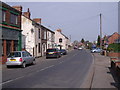
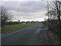
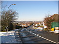
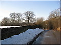
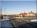
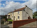
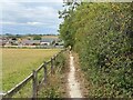
You are looking at a built-up area that covers 31.1 hectares within the town of Lower Pilsley. This compact residential zone sits within England and functions as a distinct neighbourhood within a larger urban setting. The area is defined by its established nature, categorised as a built-up area, which suggests a mature environment with established infrastructure. Residents here experience daily life within a community that has developed over time, offering a settled atmosphere rather than rapid expansion. The location serves as a functional part of the local town structure, providing housing and living space for thousands. Homebuyers will find it situated in a practical urban context where services and neighbours are closely integrated. The area does not span vast distances, meaning the residential zone is contained and accessible. Lower Pilsley represents a specific pocket of housing that forms part of the wider regional network in Derbyshire. The presence of significant housing stock indicates a long-standing community. You will find homes here that cater to those seeking a established residential setting. The area's size ensures that you are not isolated, yet you maintain a specific local identity distinct from the wider town centre. Living in Lower Pilsley means settling into a structured, built-up environment with clear boundaries and defined community needs.
- Area Type
- Built Up Area 250
- Area Size
- 31.1 hectares
- Population
- Not available
- Population Density
- Not available
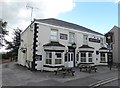
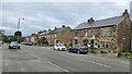
Your daily lifestyle in Lower Pilsley revolves around a small but functional cluster of amenities. There are five retail outlets within practical reach, including a Co-op Petrol, a Co-op North, and a Tesco Clay. These locations provide essential shopping needs for groceries and general goods without a long journey into the main town centre. You can purchase everyday items locally, which saves travel time and supports convenience. Nearby transport links offer further movement capabilities with two rail stations available: Alfreton Railway Station and Chesterfield Railway Station. These stations provide access to wider rail networks for trips outside the immediate locality. Additionally, one bus service is noted at the Coach Station, offering another option for regional travel. While the amenities list is specific to retail and transport links, the presence of these key facilities enhances the practicality of living here. You have a Co-op for fuel and fresh food, and train stations at your fingertips for commuting. The environment balances self-sufficiency in shops with connectivity to broader destinations via rail. Living in Lower Pilsley means your essential daily needs are met close by, reducing friction in your routine chores and commutes.
Amenities
Schools
Families considering Lower Pilsley will find Park House Primary School as the main educational provision nearby. This institution is a primary school that holds a 'good' Ofsted rating. The presence of a primary school with this rating indicates that the area supports early years education with a standard defined by the government inspectorate. Because the median age is 70, the immediate demographic surrounding the school is not necessarily one of young children, yet the school remains a key facility for the wider catchment. The mix is limited to this single primary option within the listed data, meaning secondary schools are located further away or not included in this specific local assessment. For families, this focal point suggests a reliance on Park House Primary for early education needs. The travel distance to other schools is not detailed, but you should verify travel times for older children separately. You cannot assume a comprehensive diversity of school types based on the current listing, as only the primary tier is identified. Parents should check admission zones carefully, as the proximity of a 'good' rated primary school does not guarantee other high-performing options nearby for teenagers. Education in Lower Pilsley is as much about the local landscape as the classroom walls.
| Rank | School | Type | Entry gender | Ages |
|---|
Explore more schools in this area
Go to Schools tabDemographics
The community profile in Lower Pilsley reveals a population with a median age of 70. This figure indicates that the neighbourhood is dominated by older residents, creating a demographic that skews significantly towards retirement age or later life. The most common age grouping aligns with this high median, suggesting a quiet, settled population. Home ownership stands at 83%, which is exceptionally high compared to the national average. This statistic points to a neighbourhood where residents have stayed put or purchased their homes long ago, rather than a area dominated by short-term renters. The high ownership rate reinforces the stability within the community. You will find fewer young professionals or families moving in quickly, as the housing stock and demographic makeup cater largely to those staying in this region long-term. This lack of frequent turnover creates a predictable environment where neighbours know one another. The accommodation type data confirms that the population structure supports this high ownership figure. There is little evidence of large-scale student housing or temporary lodging units in this specific zone. The ethnic and religious breakdown is not detailed in available records, but the high ownership rate remains the defining characteristic of the social fabric. Deprivation levels are not specified, but the stability of home ownership often correlates with consistent community engagement. Living in Lower Pilsley means joining a community where residents have deep roots.
Household Size
Accommodation Type
Tenure
Ethnic Group
Religion
Household Composition
Age
Household Deprivation
NS-SEC
Explore more demographic insights in this area
Go to Demographics tabPlanning
Planning Constraints
- Crime RiskPremium