Area Overview for Loddington
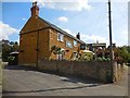
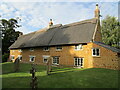
Photos of Loddington


Area Information
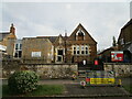
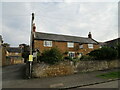
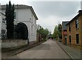
Loddington is a compact built-up area in England, spanning 23.3 hectares. It is a small but well-defined community, characterised by its mature population and practical infrastructure. The area’s residents benefit from proximity to essential services, including a railway station and local retail options. With a median age of 70, Loddington is home to a predominantly older demographic, which shapes the social fabric of the area. Daily life here is grounded in routine, with a focus on accessibility and stability. The presence of two Church of England primary schools underscores the community’s emphasis on education, while the high broadband score of 96 ensures reliable digital connectivity for residents. Loddington’s compact size means amenities are within practical reach, making it suitable for those prioritising convenience over sprawling urban environments. For buyers, the area offers a blend of established housing stock and a low crime risk, reflecting a balanced approach to living in a settled, low-maintenance setting.
- Area Type
- Built Up Area 250
- Area Size
- 23.3 hectares
- Population
- Not available
- Population Density
- Not available
Loddington’s residents have access to a range of practical amenities within easy reach. The area includes five retail outlets, such as Asda Rothwell, Morrisons Daily, and Co-op Rothwell, ensuring everyday shopping needs are met. The presence of Kettering Railway Station and a bus interchange adds convenience for travel, whether for work, leisure, or visiting nearby areas. While the data does not mention parks or leisure facilities, the compact size of the area suggests that local amenities are efficiently arranged. The combination of retail options and transport links fosters a self-contained lifestyle, reducing the need for long commutes. For those who value accessibility and a straightforward, no-frills approach to daily living, Loddington offers a functional, well-served environment.
Amenities
Schools
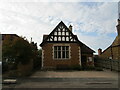
Loddington is served by two primary schools: Loddington Church of England Primary School and Loddington CofE (VA) Primary School. Both are Church of England institutions, reflecting the area’s religious and educational priorities. The presence of two primary schools within close proximity offers families multiple options for early education, though the data does not provide Ofsted ratings or academic performance metrics. The dual availability of primary schools may reduce competition for places and provide flexibility for parents. However, the absence of secondary schools in the data suggests that families may need to look beyond Loddington for secondary education. For those prioritising a strong foundation in primary schooling, the local schools offer a consistent, faith-based educational environment.
| Rank | School | Type | Entry gender | Ages |
|---|
Explore more schools in this area
Go to Schools tabDemographics
Loddington’s population is predominantly older, with a median age of 70. This suggests a community where retirees and long-term residents form the majority. Home ownership is high, with 78% of households owning their properties, indicating a stable, settled population. The data does not specify household composition or accommodation types, but the overall profile points to a low turnover of residents. The area’s demographic is not defined by ethnic or religious diversity, as these categories are listed as “total” in the data. This implies a homogenous community, which may appeal to those seeking a familiar, consistent social environment. The absence of detailed deprivation metrics means the area’s quality of life cannot be assessed in terms of socioeconomic challenges, but the high home ownership rate and low crime risk suggest a generally secure and stable living environment.
Household Size
Accommodation Type
Tenure
Ethnic Group
Religion
Household Composition
Age
Household Deprivation
NS-SEC
Explore more demographic insights in this area
Go to Demographics tabPlanning
Planning Constraints
- Crime RiskPremium