Area Overview for LE8 6LJ
Photos of LE8 6LJ
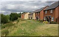
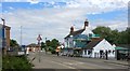
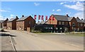
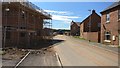

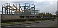

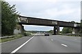
24 photos from this area
Area Information
Key information about the LE8 6LJ including its size, population, and administrative classification.
- Area Type
- Postcode
- Area Size
- 3.2 hectares
- Population
- 2350
- Population Density
- 366 people/km²
House Prices in LE8 6LJ
7
Properties
£240,000
Average Sold Price
£240,000
Lowest Price
£240,000
Highest Price
Showing 7 properties
| Address | Type | Beds | Baths | Last Sale Price | Last Sale Date | |
|---|---|---|---|---|---|---|
| 1 Dog And Gun Lane, Whetstone, LE8 6LJ | Bungalow | 2 | - | £240,000 | Jul 2017 | |
| Managers Accommodation, Dog & Gun, Dog And Gun Lane, Whetstone, LE8 6LJ | Retail | - | - | - | - | |
| Dog & Gun, Dog And Gun Lane, Whetstone, LE8 6LJ | restaurant_cafe | - | - | - | - | |
| Jsj Cakes And Catering, Unit 3, Sam Brown Industrial Units, Dog And Gun Lane, Whetstone, LE8 6LJ | Industrial | - | - | - | - | |
| Leicester Nomads Cc, Dog And Gun Lane, Whetstone, LE8 6LJ | Leisure | - | - | - | - | |
| Wpm Europe Ltd, Units 1 And 2, Sam Brown Industrial Units, Dog And Gun Lane, Whetstone, LE8 6LJ | storage_distribution | - | - | - | - | |
| The Co-operative Group Ltd, Atm At Co Op, Dog And Gun Lane, Whetstone, LE8 6LJ | shop | - | - | - | - |
Energy Efficiency in LE8 6LJ
Amenities
Schools
| Rank | School | Type | Entry gender | Ages |
|---|
Explore more schools in this area
Go to Schools tabDemographics
Household Size
Family (3-5 people)
most common
Accommodation Type
Houses
most common
Tenure
88
majority
Ethnic Group
White
most common
Religion
N/A
most common
Household Composition
N/A
most common
Age
47
median
Adults (30-64 years)
most common
Household Deprivation
N/A
with no deprivation
NS-SEC
45
in Lower managerial occupations
Explore more demographic insights in this area
Go to Demographics tabPlanning
Planning Constraints
- Flood RiskPremium
- Ramsar Wetland SitesPremium
- Area of Outstanding Natural BeautyPremium
- Protected Nature ReservePremium
- Protected WoodlandPremium