Area Overview for LE7 3FQ
Photos of LE7 3FQ


Area Information
Living in LE7 3FQ means inhabiting a small, tightly packed residential cluster in England, home to 1,847 people spread across a compact area. With a population density of 816 people per square kilometre, this postcode reflects a community that values proximity and convenience. The area is defined by its modest scale, offering a quiet, localised environment where daily life is shaped by nearby amenities and established infrastructure. Residents benefit from a mix of retail and transport options, including supermarkets, petrol stations, and multiple railway stations. The demographic profile suggests a mature, stable population, with adults aged 30–64 forming the majority. This is a place where home ownership is prevalent, and the housing stock is primarily composed of detached or semi-detached homes. For those seeking a balance between practicality and accessibility, LE7 3FQ provides a compact yet well-connected base, ideal for those prioritising security, low crime, and reliable digital connectivity.
- Area Type
- Postcode
- Area Size
- Not available
- Population
- 1847
- Population Density
- 816 people/km²
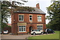
The property market in LE7 3FQ is characterised by high home ownership, with 89% of residents living in their own homes. This suggests a community of long-term residents rather than a rental-heavy market. The accommodation type is predominantly houses, which is unusual for areas with smaller footprints, indicating a focus on single-family homes. Given the area’s compact size, the housing stock is likely limited, with fewer options for buyers seeking larger properties. The high proportion of owner-occupied homes may mean that the rental market is constrained, making it challenging for new buyers to find investment opportunities. However, the presence of nearby rail and metro stations, such as Syston and Sileby, adds value to properties by enhancing connectivity. For those prioritising security and stability, LE7 3FQ offers a niche market with established homes in a low-risk environment.
House Prices in LE7 3FQ
No properties found in this postcode.
Energy Efficiency in LE7 3FQ
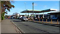
The lifestyle in LE7 3FQ is shaped by its proximity to essential amenities. Retail options include M&S Branston BP, Iceland Leicester, and Morrisons Daily, offering everyday shopping needs within reach. The area’s railway and metro stations—such as Syston and Great Central Railway—provide access to broader networks, enabling easy travel to nearby towns. While the area is small, its practical layout ensures that residents can access shops, transport, and services without needing to travel far. The absence of large-scale leisure facilities or parks is balanced by the quiet, residential character of the neighbourhood. This makes LE7 3FQ ideal for those seeking a straightforward, low-maintenance lifestyle with reliable access to daily necessities. The compact nature of the area means that amenities are concentrated, reducing the need for long commutes while maintaining a sense of community cohesion.
Amenities
Schools
| Rank | School | Type | Entry gender | Ages |
|---|
Explore more schools in this area
Go to Schools tabDemographics
The community in LE7 3FQ is predominantly composed of adults aged 30–64, with a median age of 47. This suggests a mature, established population, likely with long-term ties to the area. Home ownership is exceptionally high at 89%, indicating a stable, long-term resident base rather than a transient rental market. The accommodation type is primarily houses, which aligns with the higher proportion of owner-occupied properties. The predominant ethnic group is White, reflecting a homogenous demographic profile. While no specific data on deprivation is provided, the high home ownership and low crime risk suggest a relatively affluent, secure environment. The absence of significant diversity metrics does not imply a lack of inclusivity, but rather a community defined by continuity and local identity.
Household Size
Accommodation Type
Tenure
Ethnic Group
Religion
Household Composition
Age
Household Deprivation
NS-SEC
Explore more demographic insights in this area
Go to Demographics tabPlanning
Planning Constraints
- Flood RiskPremium
- Ramsar Wetland SitesPremium
- Area of Outstanding Natural BeautyPremium
- Protected Nature ReservePremium
- Protected WoodlandPremium