Area Overview for LE5 5EP
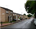
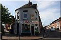
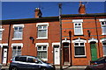
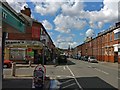
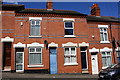
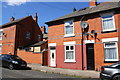
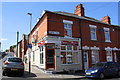
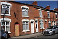
Photos of LE5 5EP


Area Information
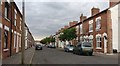
Living in LE5 5EP offers a quiet, tightly knit residential experience in a small cluster of homes. With a population of 1,579, the area feels intimate, where daily life is shaped by proximity to essential services and transport links. The community is predominantly composed of adults aged 30–64, reflecting a mature demographic with established roots. This postcode area is characterised by a mix of retail and transport options, including nearby supermarkets like Co-op Evington and Sainsburys Leicester, as well as three railway stations within practical reach. The presence of Leicester Airport adds to the area’s connectivity, while the low flood risk and below-average crime rate contribute to a sense of security. For those seeking a balance between convenience and tranquillity, LE5 5EP provides access to both urban amenities and a stable, low-risk environment. Its compact size means residents can easily navigate local shops, schools, and public transport, making it ideal for those prioritising ease of access over sprawling urban sprawl.
- Area Type
- Postcode
- Area Size
- Not available
- Population
- 1579
- Population Density
- 15933 people/km²
The property market in LE5 5EP is dominated by owner-occupied homes, with 66% of properties in private hands. This contrasts with areas where rental demand drives the market, indicating a more settled population. The accommodation type is predominantly houses, which are typically larger and suited to families. This suggests that the area caters to those seeking single-family homes rather than apartments or flats. For buyers, the small size of the postcode area means properties are likely to be in close proximity to one another, with limited scope for expansion. The high home ownership rate also implies a stable market, where properties may hold value over time. However, the limited number of homes means competition could be fierce, particularly for those seeking specific features like garden space or proximity to transport links.
House Prices in LE5 5EP
No properties found in this postcode.
Energy Efficiency in LE5 5EP
Residents of LE5 5EP have access to a range of nearby amenities that cater to daily needs. Retail options include Co-op Evington, Sainsburys Leicester, and Iceland Leicester, ensuring easy access to groceries and household essentials. The area’s proximity to multiple railway stations, such as Leicester Railway Station and Syston Railway Station, as well as metro lines like Rothley, facilitates convenient travel for work, shopping, or leisure. The nearby Leicester Airport offers additional connectivity for those requiring air travel. While the area does not feature prominent parks or leisure facilities, its compact size means residents can reach urban centres for cultural or recreational activities. The combination of retail, transport, and regional links creates a lifestyle that balances local convenience with broader opportunities, supporting both practical living and access to larger amenities.
Amenities
Schools
| Rank | School | Type | Entry gender | Ages |
|---|
Explore more schools in this area
Go to Schools tabDemographics
The population of LE5 5EP is 1,579, with a median age of 47 and the majority of residents falling within the 30–64 age range. This suggests a community of working-age adults and older families, rather than a younger or retired demographic. Home ownership is strong, with 66% of properties owner-occupied, indicating a stable housing market. The area is predominantly composed of houses, which aligns with the presence of a mature, family-focused population. The predominant ethnic group is Asian, reflecting the area’s cultural diversity. While specific data on deprivation is not provided, the high home ownership rate and low crime score of 79 suggest a relatively affluent and secure environment. This demographic profile supports a community where residents are likely to have long-term ties, contributing to a cohesive local identity.
Household Size
Accommodation Type
Tenure
Ethnic Group
Religion
Household Composition
Age
Household Deprivation
NS-SEC
Explore more demographic insights in this area
Go to Demographics tabPlanning
Planning Constraints
- Flood RiskPremium
- Ramsar Wetland SitesPremium
- Area of Outstanding Natural BeautyPremium
- Protected Nature ReservePremium
- Protected WoodlandPremium