Area Overview for LE5 0RJ
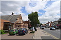
Photos of LE5 0RJ


Area Information
Living in LE5 0RJ offers a compact, residential experience in a small cluster of homes, with a population of 2005 residents. This area is defined by its proximity to practical amenities and a mix of transport options that cater to both local and regional needs. The community here is predominantly composed of adults aged 30–64, reflecting a stable demographic profile. With a low crime risk score of 81 and no flood or environmental constraints, LE5 0RJ provides a secure environment for families and individuals seeking a balanced lifestyle. Nearby, residents can access retail outlets like Iceland Uppingham and Tesco Leicester, along with railway stations such as Leicester and Syston, which link to broader networks. The area’s digital connectivity is strong, with broadband rated excellent and mobile coverage good, supporting both remote work and everyday internet use. LE5 0RJ is a practical choice for those prioritising safety, convenience, and access to essential services without the need to travel far.
- Area Type
- Postcode
- Area Size
- Not available
- Population
- 2005
- Population Density
- 4479 people/km²
The property market in LE5 0RJ is dominated by houses, with 65% of residents owning their homes. This suggests a predominantly owner-occupied area, which may indicate stability and long-term investment in the local housing stock. The small residential cluster means the available properties are limited, making the area a niche choice for buyers seeking a compact, established community. The absence of high-rise or rental-focused developments implies a quieter, more traditional environment. For buyers, this means a focus on individual homes rather than apartments or shared spaces. The proximity to rail and metro stations, such as Leicester North and Rothley, adds value by connecting residents to wider employment and leisure opportunities. However, the limited size of the area means property availability is constrained, requiring buyers to consider nearby zones for more options.
House Prices in LE5 0RJ
No properties found in this postcode.
Energy Efficiency in LE5 0RJ
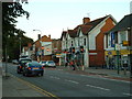
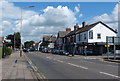
Daily life in LE5 0RJ is shaped by its proximity to retail, dining, and transport hubs. Residents can access shops like Iceland Uppingham, Tesco Leicester, and Aldi Thurmaston, offering essential goods and groceries. The area’s railway and metro stations, including Leicester North and Rothley, provide easy access to city centres and beyond, while Leicester Airport is within reach for travel. Though the area is small, its transport links ensure residents can explore broader leisure and cultural opportunities. The absence of major green spaces or parks is offset by the practicality of nearby urban amenities. The mix of retail and transport options supports a lifestyle that balances local convenience with regional connectivity. For those who enjoy a mix of shopping, commuting, and travel, LE5 0RJ offers a functional base with minimal need for long journeys.
Amenities
Schools
| Rank | School | Type | Entry gender | Ages |
|---|
Explore more schools in this area
Go to Schools tabDemographics
The population of LE5 0RJ is 2005, with a median age of 47, indicating a mature community where adults aged 30–64 form the largest age group. Home ownership rates stand at 65%, suggesting a mix of owner-occupied properties and rental units. The area is characterised by houses as the primary accommodation type, reflecting a traditional, family-oriented housing stock. The predominant ethnic group is Asian, which shapes the cultural landscape and community dynamics. This demographic profile implies a stable, established population with a focus on long-term residency. The absence of specific deprivation data means the quality of life here is likely supported by the area’s safety, transport links, and access to amenities. The low crime risk further reinforces the appeal of LE5 0RJ as a secure, low-stress environment for residents.
Household Size
Accommodation Type
Tenure
Ethnic Group
Religion
Household Composition
Age
Household Deprivation
NS-SEC
Explore more demographic insights in this area
Go to Demographics tabPlanning
Planning Constraints
- Flood RiskPremium
- Ramsar Wetland SitesPremium
- Area of Outstanding Natural BeautyPremium
- Protected Nature ReservePremium
- Protected WoodlandPremium