Area Overview for LE11 5EQ
Photos of LE11 5EQ

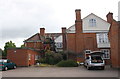
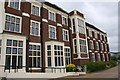
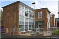
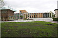
57 photos from this area
Area Information
Key information about the LE11 5EQ including its size, population, and administrative classification.
- Area Type
- Postcode
- Area Size
- 1.5 hectares
- Population
- 2409
- Population Density
- 6807 people/km²
House Prices in LE11 5EQ
25
Properties
£241,579
Average Sold Price
£74,000
Lowest Price
£540,000
Highest Price
Showing 25 properties
| Address | Type | Beds | Baths | Last Sale Price | Last Sale Date | |
|---|---|---|---|---|---|---|
| 23 Storer Road, Loughborough, LE11 5EQ | Semi-detached | 4 | 2 | £372,000 | Dec 2022 | |
| 9 Storer Road, Loughborough, LE11 5EQ | house | - | - | £250,000 | Mar 2022 | |
| 15 Storer Road, Loughborough, LE11 5EQ | house | - | - | £273,000 | Nov 2021 | |
| 5 Storer Road, Loughborough, LE11 5EQ | house | - | - | £470,000 | Apr 2021 | |
| Lester Court Care Home, 2A Storer Road, Loughborough, LE11 5EQ | hospital_care_home | - | - | £540,000 | Apr 2019 | |
| 21 Storer Road, Loughborough, LE11 5EQ | Terraced | 4 | 1 | £274,100 | Dec 2018 | |
| 31 Storer Road, Loughborough, LE11 5EQ | house | - | - | £375,000 | Apr 2018 | |
| 33 Storer Road, Loughborough, LE11 5EQ | house | - | - | £325,000 | Dec 2016 | |
| 7 Storer Road, Loughborough, LE11 5EQ | house | 6 | 2 | £203,000 | Jun 2006 | |
| 12 Storer Road, Loughborough, LE11 5EQ | Flat | 1 | 1 | £140,000 | Oct 2004 |
Page 1 of 3
Energy Efficiency in LE11 5EQ
Amenities
Schools
| Rank | School | Type | Entry gender | Ages |
|---|
Explore more schools in this area
Go to Schools tabDemographics
Household Size
Family (3-5 people)
most common
Accommodation Type
Houses
most common
Tenure
31
majority
Ethnic Group
White
most common
Religion
N/A
most common
Household Composition
N/A
most common
Age
22
median
Young Adults (15-29 years)
most common
Household Deprivation
N/A
with no deprivation
NS-SEC
12
in Lower managerial occupations
Explore more demographic insights in this area
Go to Demographics tabPlanning
Planning Constraints
- Flood RiskPremium
- Ramsar Wetland SitesPremium
- Area of Outstanding Natural BeautyPremium
- Protected Nature ReservePremium
- Protected WoodlandPremium