Area Overview for Hathern
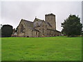
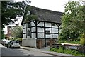
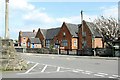
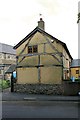
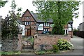
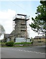
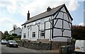
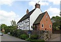
Photos of Hathern


Area Information
Living in Hathern offers a blend of practicality and accessibility, set within a compact 68.4-hectare built-up area in England. The community is defined by its mature demographic, with a median age of 70, suggesting a population that leans toward older residents. This area is well-served by transport links, including three railway stations—Loughborough, East Midlands Parkway, and Barrow upon Soar—alongside two metro stops at Loughborough Central and Quorn & Woodhouse. Nearby, East Midlands Airport is within reach, offering regional connectivity. Daily life here is supported by five retail outlets, including Asda Hathern and Morrisons Thorpe, ensuring essentials are within practical distance. The presence of Hathern Church of England Primary School, rated ‘good’ by Ofsted, adds to the appeal for families. While the area lacks overt tourist attractions, its proximity to rail and motorway networks makes it a strategic choice for commuters and those prioritising convenience over urban amenities.
- Area Type
- Built Up Area 250
- Area Size
- 68.4 hectares
- Population
- Not available
- Population Density
- Not available
Hathern’s lifestyle is shaped by its proximity to essential amenities. Retail options include Asda Hathern, Morrisons Thorpe, and Co-op Knighthorpe, ensuring daily shopping needs are met within the area. The three railway stations—Loughborough, East Midlands Parkway, and Barrow upon Soar—offer easy access to larger towns and cities, while the two metro stops provide regional connectivity. East Midlands Airport is a short distance away, facilitating travel for business or leisure. The area’s compact size means amenities are clustered closely, reducing the need for long commutes. However, the absence of parks, dining venues, or leisure facilities in the data suggests that residents may rely on nearby towns for cultural or recreational activities. The practicality of Hathern’s amenities is balanced by its limited scope for leisure, making it ideal for those prioritising convenience over urban vibrancy.
Amenities
Schools
The primary school closest to Hathern is the Hathern Church of England Primary School, which serves the local community and holds a ‘good’ Ofsted rating. This school is the only educational institution explicitly listed in the data, meaning the area’s school options are limited to primary education. Families with older children may need to look further afield for secondary schooling, which could impact the appeal of Hathern for those prioritising a full range of educational facilities. The presence of a well-rated primary school is a positive factor, but the absence of secondary schools or additional educational institutions means prospective buyers should consider proximity to larger towns for comprehensive schooling.
| Rank | School | Type | Entry gender | Ages |
|---|---|---|---|---|
| 1 | Hathern Church of England Primary School | primary | N/A | N/A |
Explore more schools in this area
Go to Schools tabDemographics
Hathern’s population is predominantly older, with a median age of 70, reflecting a community where the majority are retired or in later life stages. Home ownership is high at 76%, indicating a stable, long-term resident base. The data does not specify household types or ethnic diversity, but the overall figures suggest a cohesive, low-turnover community. The absence of detailed breakdowns on accommodation types or deprivation levels means the area’s socioeconomic profile remains broadly generalised. However, the high home ownership rate implies a focus on permanent residency rather than transient rental markets. For those considering Hathern, the demographic profile suggests a quieter, less dynamic environment compared to younger, more diverse areas. The age distribution may influence local services and amenities, with a focus on healthcare and leisure tailored to older adults.
Household Size
Accommodation Type
Tenure
Ethnic Group
Religion
Household Composition
Age
Household Deprivation
NS-SEC
Explore more demographic insights in this area
Go to Demographics tabPlanning
Planning Constraints
- Crime RiskPremium