Area Overview for Halam
Photos of Halam

Area Information
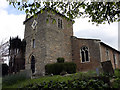
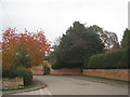
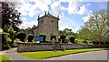
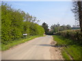
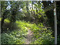
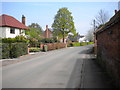
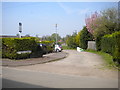
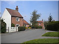
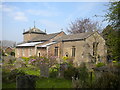
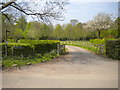
Living in Halam offers a distinctly rural experience within Newark and Sherwood district. This built-up area spans 29.0 hectares and sits approximately 1½ miles northwest of Southwell and west of Newark. The village currently holds a population of around 400–426 residents, creating a small, close-knit community. You will find Halam described as a pleasant, well-built farming village situated at the foot of a hill. This geography provides immediate access to countryside walks and a peaceful atmosphere ideal for quiet reflection. The area's character is rooted in its deep history. First recorded in 1870–72, the parish originally covered 1,310 acres with a population of 382. Today, you can walk past landmarks that frame daily life, such as the 11th–12th-century Church of St Michael the Archangel. This historic building features a medieval chancel arch and a Norman tower. Further exploration reveals an 18th-century three-storey watermill on Halam Beck. Residents also enjoy proximity to The Waggon pub, which holds the distinction of being the UK's first carbon-neutral pub and the origin of the Nottinghamshire Pie. Norwood Park Golf Course lies nearby, partly within the village boundaries. While the village maintains a tranquil setting, it benefits from historical significance and strong local identity. Homes in Halam reflect this established charm, set against a backdrop of active farming and preserved heritage.
- Area Type
- Built Up Area 250
- Area Size
- 29.0 hectares
- Population
- Not available
- Population Density
- Not available
Your daily life in Halam revolves around the village centre and immediate countryside. Retail convenience is provided by five key amenities within practical reach. You can shop at Co-op Southwell, Morrisons Daily, and M&S Southwell Green BP. These venues offer essential groceries and basics without requiring a long drive into Newark. This cluster of stores ensures you have immediate access to daily necessities. The 1½ miles to Southwell station also places you near additional commercial zones beyond the immediate village. Leisure options include Norwood Park Golf Course, which partly lies within Halam's boundaries. This facility offers a recreational outlet for residents seeking outdoor activity. The village also features significant historical attractions that double as lifestyle amenities. You can visit the 18th-century watermill on Halam Beck or explore the grounds around the Church of St Michael the Archangel. Drinking locally is available at The Waggon, a carbon-neutral pub famous for the Nottinghamshire Pie. The lifestyle here is defined by quietness and history. The presence of 17 listed buildings means streets are lined with heritage structures, creating a walkable environment rich in character. There are no large retail parks or cinema complexes immediately on-site. Instead, your leisure time is shaped by walking the hill at the foot of which the village sits, enjoying views of the surrounding fields. Whether you are a history enthusiast checking out the medieval chancel arch or a golfer booking a tee time, Halam accommodates varied interests. The character remains peaceful, with no loud nightlife or heavy traffic.
Amenities
Schools
Local education options for families living in Halam are limited to primary provision. The village hosts two primary schools: Halam CofE Primary School and Halam Church of England Primary School. These institutions serve the immediate community, reflecting the close integration of faith and local governance within the village. Both schools are located within the parish, ensuring that children can access education without travelling far from their homes in Halam. There are no secondary schools listed in the immediate vicinity of the village. This absence means that young teenagers and teenagers will eventually need to travel to Southwell or Newark for their secondary education. The presence of two Church of England primary schools indicates a specific educational ethos aligned with the Church of England. Families should consider this denomination when choosing an entry point into the local education system. The walkable distance to these schools suits families who prioritise pedestrian safety and rural access. While specific Ofsted ratings for these institutions are not provided in the current dataset, the simplicity of the local setup reduces the need for long commutes. You must plan ahead for the transition to secondary education, which likely involves a bus journey or a drive to Southwell or another nearby town. The character of Halam as a 400–426 resident village means these primary schools are small and likely offer highly personalised attention to pupils. For parents in the area, the school mix is simple: stay local for early years, then look externally for older children.
| Rank | School | Type | Entry gender | Ages |
|---|
Explore more schools in this area
Go to Schools tabDemographics
The community profile of Halam reveals a mature population. The median age stands at 70 years, indicating that older residents form the heart of this village. You are looking at a demographic where the most common age range aligns with the total population data, suggesting a stable, established resident base rather than a youthful influx. This age structure typically correlates with a slower pace of life and longer-term residency. Home ownership is the dominant form of accommodation in Halam, with 84% of households owning their property outright and through mortgage. Consequently, the rental sector represents a minor fraction of the market. This high level of ownership suggests a community with deep roots, where families and individuals have chosen to settle permanently rather than move on. The low turnover often found in such owner-occupied villages contributes to the strong sense of locality and familiarity among neighbours. While specific texture regarding household composition such as single-person homes or multi-generation families is not detailed in the available records, the overall picture points toward traditional family units or retired couples. The village does not currently present data on predominant ethnicity or religious breakdown. These missing figures mean you cannot currently assess the specific cultural or faith diversity levels. However, the high home ownership rate implies stability. You are entering an area where long-term wealth building and community integration are standard experiences for the vast majority of residents. The 1870–1990s history of the parish supports an environment where heritage and stability remain central to daily life.
Household Size
Accommodation Type
Tenure
Ethnic Group
Religion
Household Composition
Age
Household Deprivation
NS-SEC
Explore more demographic insights in this area
Go to Demographics tabPlanning
Planning Constraints
- Crime RiskPremium