Area Overview for Great Longstone
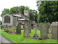
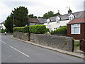
Photos of Great Longstone


Area Information
Great Longstone is a compact built-up area spanning 40 hectares, nestled in the heart of England. Its population, though not explicitly stated, is reflected in its demographic profile, with a median age of 70, suggesting a community skewed toward older residents. This area is defined by its quiet, established character, where many homes are long-standing and owner-occupied. Daily life here is likely shaped by the proximity of local amenities, including nearby railway stations and a mix of retail outlets. The area’s relatively low crime risk, with a safety score of 89, adds to its appeal as a place where residents can enjoy a stable, secure environment. While not a bustling urban centre, Great Longstone offers a blend of practicality and tranquillity, with access to essential services and transport links that connect it to surrounding towns. For those seeking a place with a mature population and a sense of community, this area may provide a straightforward, low-maintenance lifestyle.
- Area Type
- Built Up Area 250
- Area Size
- 40.0 hectares
- Population
- Not available
- Population Density
- Not available
Great Longstone’s lifestyle is shaped by its proximity to practical amenities, including five retail outlets such as Aldi Ashford, Co-op Bakewell, and Spar, which provide everyday shopping convenience. The area’s railway stations and metro stop offer access to broader regional networks, supporting both daily commutes and weekend excursions. While the data does not detail parks or leisure facilities, the presence of local shops and transport links suggests a community focused on accessibility and practicality. The combination of retail options and transport infrastructure ensures that residents can meet their daily needs without extensive travel, fostering a self-contained yet connected lifestyle.
Amenities
Schools
The nearest school to Great Longstone is Longstone CofE Primary School, which serves the local community with a good Ofsted rating. This primary school is a key resource for families in the area, offering education for younger children. However, the data does not include secondary schools or further education institutions nearby, meaning families may need to look beyond Great Longstone for comprehensive schooling. The presence of a well-rated primary school is a positive factor for those prioritising education, but prospective buyers should consider the broader school options available in the surrounding region.
| Rank | School | Type | Entry gender | Ages |
|---|
Explore more schools in this area
Go to Schools tabDemographics
The population of Great Longstone has a median age of 70, indicating a community predominantly composed of older residents. This age profile suggests a demographic that may prioritise stability and proximity to essential services. Home ownership is high, with 77% of households owning their homes, reflecting a long-term presence of residents rather than a transient population. The data does not specify household composition or accommodation types, but the overall figures imply a mix of family and single-person households. The predominant ethnic group and religious composition are not detailed, but the area’s demographics align with broader trends in rural and semi-rural England, where older populations often dominate. The high home ownership rate and mature age profile may influence local dynamics, such as the demand for healthcare services and community-focused amenities.
Household Size
Accommodation Type
Tenure
Ethnic Group
Religion
Household Composition
Age
Household Deprivation
NS-SEC
Explore more demographic insights in this area
Go to Demographics tabPlanning
Planning Constraints
- Crime RiskPremium