Area Overview for Great Addington
Photos of Great Addington


Area Information
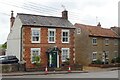
Great Addington is a compact built-up area in England, spanning 20.5 hectares. Its small size means it is not a sprawling suburb but a focused, tight-knit community. The area’s median age is 70, indicating a population skewed toward older residents. This demographic shapes daily life, with a quiet rhythm and a slower pace compared to busier urban centres. Living here offers proximity to essential services, with five retail outlets within practical reach, including Asda Raunds and Aldi Attley. The area’s compact nature makes it easy to navigate on foot or by bike, though major roads like the A43 are nearby for those needing faster travel. Great Addington is not a place for those seeking a young, fast-paced environment but suits those prioritising stability, safety, and a calm lifestyle. Its two primary schools, Great Addington Church of England Primary School and Great Addington CofE Primary School, serve the local community, reinforcing its family-friendly character. The area’s small size and mature population create a distinct atmosphere, ideal for those seeking a low-maintenance, secure neighbourhood.
- Area Type
- Built Up Area 250
- Area Size
- 20.5 hectares
- Population
- Not available
- Population Density
- Not available
Great Addington’s lifestyle is defined by its proximity to retail, transport, and community hubs. Five retail outlets, including Asda Raunds, M&S Raunds Wellingborough BP, and Aldi Attley, provide access to groceries, clothing, and everyday essentials. The Wellingborough and Kettering railway stations offer links to nearby towns, while a bus interchange ensures local mobility. The area’s small size means amenities are within walking or cycling distance, fostering a sense of convenience. However, the lack of larger leisure facilities or parks is notable, which may appeal to those prioritising simplicity over extensive recreational options. The presence of two primary schools and a stable community further enhance the area’s appeal, creating a self-contained environment where daily needs are met without the need for long commutes.
Amenities
Schools
Great Addington has two primary schools: Great Addington Church of England Primary School and Great Addington CofE Primary School. Both are state-funded and serve the local community, catering to children from pre-school through to Year 6. The presence of two primary schools within the area ensures that families have access to education without needing to travel far. However, the data does not provide Ofsted ratings or academic performance metrics, so it is unclear how these schools compare to others in the region. The dual presence of similar school names may indicate a single institution with two campuses or a shared site. For families, this means a reliable, local education option, though further research would be needed to assess teaching quality or facilities. The schools’ existence reinforces the area’s appeal to those prioritising convenience and a strong local network.
| Rank | School | Type | Entry gender | Ages |
|---|
Explore more schools in this area
Go to Schools tabDemographics
Great Addington has a median age of 70, the highest in the dataset, suggesting a population dominated by older adults. This age profile influences household composition, with a higher proportion of single-person households or couples in later life. Home ownership is strong, with 74% of residents owning their homes, indicating a stable, long-term community. The accommodation types are not specified, but the high home ownership rate suggests a mix of semi-detached houses, terraced homes, and bungalows, typical of older built-up areas. The data does not provide details on ethnic diversity or religious composition, but the absence of specific figures implies a homogeneous population. The area’s low crime risk score of 78/100 further supports the idea of a safe, secure environment. However, the lack of data on deprivation or income levels means the quality of life for residents cannot be fully assessed beyond the safety and stability already noted.