Area Overview for Grantham St. Wulfram's Ward
Photos of Grantham St. Wulfram's Ward
Area Information
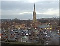
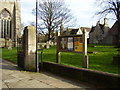
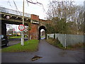
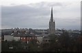
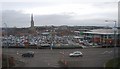
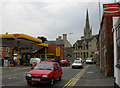
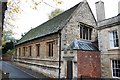
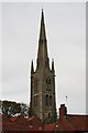
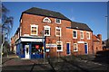
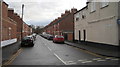
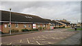
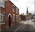
Grantham St. Wulfram's Ward occupies a central position within the historic core of Grantham, forming part of the South Kesteven district in Lincolnshire. This electoral ward covers an area of 1.9 square kilometres and sits approximately 52.92°N, 0.64°W, near the River Witham. The location encompasses the town's main retail and commercial district, specifically the High Street, which features historic buildings alongside postwar retail developments. Boundaries include Westgate, Brook Street, Castlegate, and St Peter's Hill, positioning the ward west of the A1 road. A defining landmark within the boundary is the Church of St Wulfram, a listed building that has served the community since at least the 11th century. Some early settlers in the area arrived from Crowland Abbey during the Danish period. The ward lies adjacent to key transport routes, including the A1 to the west and the A52 to the south-east. Grantham's railway station provides East Coast Main Line services for residents. Living in Grantham St. Wulfram's Ward means residing in a predominantly medieval market town environment with modern connectivity. The mix of historic architecture and commercial activity defines the daily experience for those choosing homes in this specific district.
- Area Type
- District Borough Unitary Ward
- Area Size
- 1.9 km²
- Population
- Not available
- Population Density
- Not available
Demographics
The community within Grantham St. Wulfram's Ward has a distinctly older demographic profile compared to the national average. The median age for residents is 70 years old, indicating that the majority of the population falls into older age brackets. The ward contains 68 per cent of owner-occupied homes, suggesting a stable community with relatively low tenant turnover. Home ownership levels in Grantham St. Wulfram's Ward are significantly higher than typical urban rental markets, which often see lower ownership rates. Accommodation types in the area reflect this ownership dominance, though specific breakdowns between houses and flats are not provided in the available figures. The ward's high home ownership percentage suggests that many residents have deep local roots. While specific ethnic group data and religious statistics are not included in the current records, the area functions as a settled residential district within South Kesteven. The age profile implies that daily life here often revolves around retirement and established local networks rather than transient populations. A borough unitary ward typically serves as an administrative division for local governance. Living in Grantham St. Wulfram's Ward offers stability for those seeking permanent residences in a historic setting.
Household Size
Accommodation Type
Tenure
Ethnic Group
Religion
Household Composition
Age
Household Deprivation
NS-SEC
Explore more demographic insights in this area
Go to Demographics tabPlanning
Planning Constraints
- Flood RiskPremium
- Ramsar Wetland SitesPremium
- Area of Outstanding Natural BeautyPremium
- Protected Nature ReservePremium
- Protected WoodlandPremium
- Crime RiskPremium