Area Overview for Egmanton
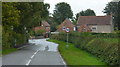
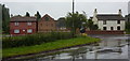
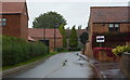
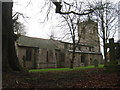
Photos of Egmanton


Area Information
Egmanton is a compact built-up area spanning 24.4 hectares, situated in England. Its character is shaped by a population with a median age of 70, reflecting a community predominantly composed of older residents. This demographic suggests a quieter, more settled environment, where daily life is likely centred around local amenities and familiar routines. The area is not defined by sprawling suburbs but by a focused, town-like layout, with homes and services clustered closely. While specific details about cultural or social activities are not provided, the presence of nearby retail outlets and an airport hints at practical conveniences for residents. Egmanton’s appeal lies in its simplicity: a place where the pace of life is measured, and the community is likely to be tight-knit, with a strong emphasis on local connections. For those seeking a low-maintenance lifestyle, Egmanton offers a straightforward, no-frills existence, with homes and amenities arranged to serve the needs of its older population.
- Area Type
- Built Up Area 250
- Area Size
- 24.4 hectares
- Population
- Not available
- Population Density
- Not available
Residents of Egmanton have access to a range of nearby amenities, including five retail outlets such as Co-op Tuxford, Waitrose Little Waitrose, and Lincolnshire Co-operative Co. These shops provide essential services and grocery options, supporting daily life with convenience. The presence of an airport, Retford Gamston Airport, adds to the area’s practicality, offering residents easy access to travel opportunities. While the data does not mention parks, leisure facilities, or dining options, the availability of retail and transport links suggests a functional, service-oriented lifestyle. The proximity to these amenities means that residents can meet their shopping and travel needs without venturing far, contributing to a self-contained, efficient living environment.
Amenities
Schools
| Rank | A + A* % | School | Type | Entry gender | Ages |
|---|
Explore more schools in this area
Go to Schools tabDemographics
Egmanton’s population is defined by a median age of 70, placing it well above the national average. This suggests a community where older residents predominate, with fewer young families or working-age individuals. The home ownership rate of 74% indicates that most residents live in properties they own, which can contribute to a sense of stability and long-term residency. However, the data does not specify household composition or accommodation types, so it is unclear whether the area includes a mix of family homes, single-person residences, or other configurations. The lack of detailed information on ethnic groups or religious affiliations means that the area’s diversity remains unexplored in this context. For those considering Egmanton, the demographic profile suggests a place where the needs of older adults are likely prioritised, with services and infrastructure tailored to their preferences.
Household Size
Accommodation Type
Tenure
Ethnic Group
Religion
Household Composition
Age
Household Deprivation
NS-SEC
Explore more demographic insights in this area
Go to Demographics tabPlanning
Planning Constraints
- Crime RiskLocked