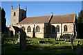
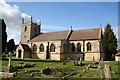
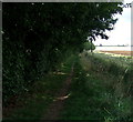
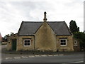
Area Overview for Dunston
Photos of Dunston


Area Information
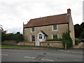
Dunston is a compact built-up area in England, spanning 34.7 hectares, with a population characterised by a median age of 70. This suggests a community skewed towards older residents, many of whom may have long-standing ties to the area. Daily life here is shaped by its modest size and proximity to key amenities. The presence of Dunston St Peter’s Church of England Primary School underscores its appeal to families, while the nearby Metheringham Railway Station and RAF Waddington offer practical connectivity. Residents benefit from a low crime risk, with a safety score of 88, reflecting a secure environment. The area’s charm lies in its simplicity—local shops, a single railway link, and a quiet, established character. For those seeking a place with a mature demographic and minimal urban sprawl, Dunston offers a straightforward, low-maintenance lifestyle. Its compact footprint means residents can access essential services without lengthy commutes, though the area’s appeal may be limited to those prioritising tranquility over sprawling amenities.
- Area Type
- Built Up Area 250
- Area Size
- 34.7 hectares
- Population
- Not available
- Population Density
- Not available
Residents of Dunston have access to a selection of local amenities within practical reach. The area includes five retail outlets, such as Lincolnshire Co-operative Co and Spar, providing basic shopping needs. The Metheringham Railway Station offers rail connectivity, while RAF Waddington is a notable nearby landmark, potentially offering employment or travel opportunities. The absence of larger retail centres or entertainment venues means daily life revolves around local shops and community services. The area’s character is defined by its simplicity—convenient for those prioritising ease of access over expansive leisure options. For buyers, this means a lifestyle focused on essentials, with the need to travel further for more diverse amenities.
Amenities
Schools
Dunston’s primary education offering is Dunston St Peter’s Church of England Primary School, which holds an Ofsted rating of ‘good’. This single school serves the area’s younger residents, though no secondary schools are listed in the data. The presence of a primary school with a positive rating is a key draw for families, though those requiring secondary education may need to look beyond Dunston. The school’s rating indicates a satisfactory standard of teaching and facilities, but the absence of further educational institutions means families should plan for commuting to nearby towns. For buyers prioritising schools, this is a positive feature, but the limited range of educational options may be a consideration for those with older children.
| Rank | School | Type | Entry gender | Ages |
|---|
Explore more schools in this area
Go to Schools tabDemographics
Dunston’s population is predominantly older, with a median age of 70, indicating a community where retirees or long-term residents form the majority. Home ownership is high at 82%, suggesting a stable, settled population with strong ties to the area. The data does not specify household composition or accommodation types, but the high ownership rate implies a mix of owner-occupied homes, likely including semi-detached or terraced properties. The absence of detailed diversity statistics means the area’s ethnic and religious composition remains unspecified, though the figures provided suggest a homogenous demographic. The high median age may influence local services and amenities, with a focus on accessibility and healthcare. For buyers, this profile indicates a community with a distinct character, where property values may reflect long-term stability rather than rapid growth.
Household Size
Accommodation Type
Tenure
Ethnic Group
Religion
Household Composition
Age
Household Deprivation
NS-SEC
Explore more demographic insights in this area
Go to Demographics tabPlanning
Planning Constraints
- Crime RiskPremium