Area Overview for DE73 6UH
Photos of DE73 6UH

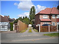

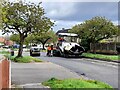
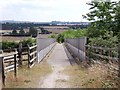
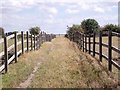
18 photos from this area
Area Information
Key information about the DE73 6UH including its size, population, and administrative classification.
- Area Type
- Postcode
- Area Size
- 6872 m²
- Population
- 2078
- Population Density
- 3028 people/km²
House Prices in DE73 6UH
16
Properties
£153,227
Average Sold Price
£34,000
Lowest Price
£242,000
Highest Price
Showing 16 properties
| Address | Type | Beds | Baths | Last Sale Price | Last Sale Date | |
|---|---|---|---|---|---|---|
| 7 Walnut Close, Derby, DE73 6UH | house | - | - | £242,000 | Aug 2022 | |
| 17 Walnut Close, Derby, DE73 6UH | house | - | - | £200,000 | Oct 2021 | |
| 1 Walnut Close, Derby, DE73 6UH | house | - | - | £208,000 | Sep 2021 | |
| 5 Walnut Close, Derby, DE73 6UH | house | - | - | £230,000 | Jun 2021 | |
| 6 Walnut Close, Derby, DE73 6UH | Semi-detached | 4 | 1 | £184,000 | Aug 2019 | |
| 4 Walnut Close, Derby, DE73 6UH | Semi-detached | 3 | - | £141,000 | May 2014 | |
| 2 Walnut Close, Derby, DE73 6UH | house | 3 | - | £120,000 | Apr 2014 | |
| 14 Walnut Close, Derby, DE73 6UH | Terraced | - | - | £150,000 | Jul 2007 | |
| 10 Walnut Close, Derby, DE73 6UH | house | - | - | £97,000 | Feb 2003 | |
| 8 Walnut Close, Derby, DE73 6UH | house | - | - | £79,500 | Oct 2001 |
Page 1 of 2
Energy Efficiency in DE73 6UH
Amenities
Schools
| Rank | School | Type | Entry gender | Ages |
|---|
Explore more schools in this area
Go to Schools tabDemographics
Household Size
Family (3-5 people)
most common
Accommodation Type
Houses
most common
Tenure
61
majority
Ethnic Group
White
most common
Religion
N/A
most common
Household Composition
N/A
most common
Age
47
median
Adults (30-64 years)
most common
Household Deprivation
N/A
with no deprivation
NS-SEC
35
in Lower managerial occupations
Explore more demographic insights in this area
Go to Demographics tabPlanning
Planning Constraints
- Flood RiskPremium
- Ramsar Wetland SitesPremium
- Area of Outstanding Natural BeautyPremium
- Protected Nature ReservePremium
- Protected WoodlandPremium