Area Overview for DE7 7AF
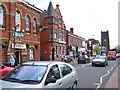
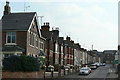
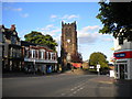
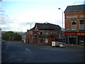
Photos of DE7 7AF


Area Information
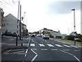
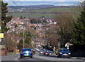
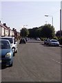
Living in DE7 7AF offers a quiet, residential lifestyle in a small cluster of homes. With a population of 1,598, the area is compact, making it ideal for those seeking a close-knit community. The median age of 47 suggests a mature demographic, with most residents falling between 30 and 64 years old. This is a place where homeownership is common — 61% of homes are owner-occupied — and the housing stock is predominantly houses rather than flats. Daily life here is shaped by proximity to local amenities, including retail outlets like Iceland Heanor and Aldi Marlpool, and rail links to Langley Mill, Ilkeston, and Belper stations. The area’s broadband score of 97 ensures reliable internet, while mobile coverage of 85 is sufficient for most needs. Though small, DE7 7AF balances practicality with access to essential services, making it a viable choice for families and professionals seeking a stable, low-maintenance environment.
- Area Type
- Postcode
- Area Size
- Not available
- Population
- 1598
- Population Density
- 4035 people/km²
The property market in DE7 7AF is characterised by a high proportion of owner-occupied homes — 61% — with houses forming the majority of the housing stock. This suggests a market skewed towards long-term residency rather than a rental-focused area. The small size of the postcode area means the housing stock is limited, which could lead to competition for available properties. Buyers should consider the local context: the presence of nearby rail stations and retail amenities may enhance the appeal of homes here, but the area’s compact nature means proximity to these services is key. As houses dominate, potential buyers may find fewer modern developments or flats, which could be a consideration for those seeking specific property types.
House Prices in DE7 7AF
No properties found in this postcode.
Energy Efficiency in DE7 7AF
The lifestyle in DE7 7AF is defined by its proximity to essential amenities. Retail options include Iceland Heanor, Aldi Marlpool, and Tesco Heanor, providing access to groceries and household goods within practical reach. Rail stations such as Langley Mill, Ilkeston, and Belper offer connections to nearby towns, enhancing mobility for commuters. While the area does not list parks or leisure facilities, the availability of retail and transport infrastructure suggests a focus on convenience over expansive recreational spaces. The compact nature of the postcode means residents can access daily necessities without long journeys, though those seeking larger green spaces may need to look beyond the immediate vicinity.
Amenities
Schools
Residents of DE7 7AF have access to two notable schools. Mundy CofE Junior School is a primary school with a good Ofsted rating, providing education for younger children in the area. Jasmine House School is a special school, also rated good, offering tailored support for students with specific needs. The combination of a primary school and a special school suggests the area caters to a range of educational requirements, which is beneficial for families with children of varying ages or needs. While no other schools are listed, the presence of these institutions indicates a focus on accessible, quality education within the community.
| Rank | School | Type | Entry gender | Ages |
|---|
Explore more schools in this area
Go to Schools tabDemographics
The community in DE7 7AF is predominantly composed of adults aged 30 to 64, with a median age of 47. Homeownership stands at 61%, reflecting a mix of long-term residents and those who have chosen to settle in the area. The accommodation type is primarily houses, which is notable in a region where flats are more common. The predominant ethnic group is White, and no specific data on deprivation or diversity beyond this is provided. The age profile suggests a stable population with fewer young families or elderly residents, which may influence local services and amenities. For buyers, this demographic profile indicates a mature market with homes likely to remain in private ownership rather than being subject to frequent rental turnover.
Household Size
Accommodation Type
Tenure
Ethnic Group
Religion
Household Composition
Age
Household Deprivation
NS-SEC
Explore more demographic insights in this area
Go to Demographics tabPlanning
Planning Constraints
- Flood RiskPremium
- Ramsar Wetland SitesPremium
- Area of Outstanding Natural BeautyPremium
- Protected Nature ReservePremium
- Protected WoodlandPremium