Area Overview for DE11 7JY
Photos of DE11 7JY
Area Information
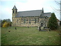
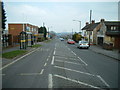
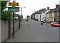
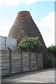
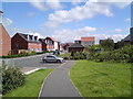
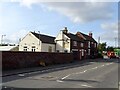
Living in DE11 7JY means residing in a compact, densely populated residential cluster in England’s East Midlands. The area, part of the village of Woodville, spans 7,299 square metres and is home to 1,497 people, translating to a population density of 205,093 per square kilometre. This small postcode area lies two miles east of Swadlincote, centred around the A511’s Tollgate junction. Woodville’s character blends suburban housing with remnants of its industrial past, including red brick mining settlements and former factories now repurposed as housing. The village’s history dates to the 19th century, with St Stephen’s Church (built 1846) and a railway station that closed in 1947. Today, daily life is shaped by local amenities like Sainsburys and Tesco, proximity to Burton-upon-Trent, and a community with a median age of 47. The area’s compact size and high density mean residents live close to shops, schools, and transport links, though its location in the top 20% most deprived areas in South Derbyshire suggests challenges in public services and infrastructure.
- Area Type
- Postcode
- Area Size
- 7299 m²
- Population
- 1497
- Population Density
- 4393 people/km²
DE11 7JY is predominantly an owner-occupied area, with 86% of homes owned by residents rather than rented. The accommodation type is primarily houses, reflecting a suburban, family-oriented housing stock. This contrasts with areas dominated by flats or rental properties, suggesting a focus on long-term residency and property investment. The small postcode area’s limited size means the housing market is tightly bound to local demand, with limited scope for expansion. Proximity to Swadlincote and the A511 may offer some connectivity to larger towns, but the area’s compact nature means buyers should consider nearby suburbs for broader options. The high home ownership rate indicates a stable market, though the area’s deprivation ranking may affect property values or investment appeal.
House Prices in DE11 7JY
Showing 8 properties
| Address | Type | Beds | Baths | Last Sale Price | Last Sale Date | |
|---|---|---|---|---|---|---|
| Sharpswood Barn, Wood Farm Lane, Woodville, Swadlincote, DE11 7JY | Semi-detached | 4 | 2 | £305,000 | Oct 2013 | |
| 2 Wood Farm Lane, Woodville, Swadlincote, DE11 7JY | house | 4 | - | £242,000 | Oct 2011 | |
| 1 Wood Farm Lane, Woodville, Swadlincote, DE11 7JY | Detached | - | - | £160,000 | Nov 2006 | |
| 3 Wood Farm Lane, Woodville, Swadlincote, DE11 7JY | Detached | - | - | £110,000 | Jun 2001 | |
| Wood Farm House, Wood Farm Lane, Woodville, Swadlincote, DE11 7JY | Detached | 5 | 3 | £230,000 | Oct 2000 | |
| The Bungalow, Wood Farm Lane, Woodville, Swadlincote, DE11 7JY | Detached | - | - | £78,000 | Nov 1999 | |
| Farm View, Wood Farm Lane, Woodville, Swadlincote, DE11 7JY | Detached | 3 | 3 | - | - | |
| Bluebell Barn, Wood Farm Lane, Woodville, Swadlincote, DE11 7JY | Semi-detached | - | - | - | - |
Energy Efficiency in DE11 7JY
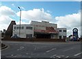
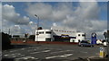
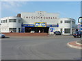
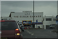
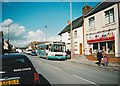
Residents of DE11 7JY have access to essential amenities within practical reach. Retail options include Asda Woodville Burton, Tesco Woodville, and Sainsburys Swadlincote, providing daily shopping convenience. The area’s schools, including infant and junior schools off High Street, cater to local families. Woodville Library and the Scout Group offer community engagement, while the former industrial sites like Mount Pleasant now host housing developments. The village’s character combines suburban living with remnants of its industrial past, such as the Woodhouse Business Centre and Pool Street. The A511 and nearby rail links connect residents to Burton-upon-Trent and Ashby-de-la-Zouch, though the area’s compact size means local amenities dominate daily life. The presence of a 24-hour petrol station and Masseys DIY (established 1947) adds to the practicality of everyday living.
Amenities
Schools
| Rank | School | Type | Entry gender | Ages |
|---|
Explore more schools in this area
Go to Schools tabDemographics
DE11 7JY’s population of 1,497 is predominantly adults aged 30–64, with a median age of 47. Eighty-six per cent of residents own their homes, reflecting a stable, owner-occupied community. The area’s accommodation is primarily houses, with no mention of flats or apartments. The predominant ethnic group is White, though specific diversity statistics are not provided. The area falls within the top 20% most deprived in South Derbyshire, which may impact access to high-quality public services or amenities. This demographic profile suggests a mature, established community with a focus on homeownership, but the deprivation ranking indicates potential gaps in resources such as healthcare or education. The high home ownership rate also implies long-term residency, with residents likely prioritising stability over mobility.
Household Size
Accommodation Type
Tenure
Ethnic Group
Religion
Household Composition
Age
Household Deprivation
NS-SEC
Explore more demographic insights in this area
Go to Demographics tabPlanning
Planning Constraints
- Flood RiskPremium
- Ramsar Wetland SitesPremium
- Area of Outstanding Natural BeautyPremium
- Protected Nature ReservePremium
- Protected WoodlandPremium