Area Overview for Corbar Ward
Photos of Corbar Ward

Area Information
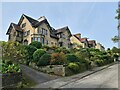
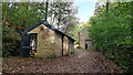
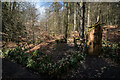
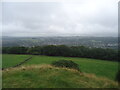
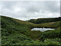
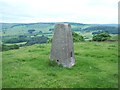
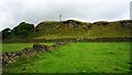
Living in Corbar Ward offers a distinct experience within Sefton, defined by its small footprint and quiet character. This district borough unitary ward covers just 7.9 km², creating a compact environment where daily needs are readily accessible. The area is particularly notable for its higher density compared to broader borough averages, fostering a close-knit community atmosphere. You will find yourself in a space that balances residential living with specific natural assets. While the ward is relatively small, it contains protected nature reserves and protected woodland, which are key features for those who value green spaces. These designations ensure that significant portions of the landscape remain untouched by development. Current assessments indicate a pass for flood risk and Ramsar wetland sites, providing reassurance regarding major environmental hazards. However, the presence of protected areas does introduce specific planning constraints to consider. The ward is not designated as an Area of Outstanding Natural Beauty, removing a layer of high-level protection typically found in more scenic regions. Despite these planning constraints, the low flood risk score of 1.52 suggests the area is generally secure from water-related flooding. For prospective buyers, this combination of small size, natural protection, and safety ratings forms the foundation of life here. The community feels established, with a clear focus on maintaining the existing character of the ward against rapid expansion.
- Area Type
- District Borough Unitary Ward
- Area Size
- 7.9 km²
- Population
- Not available
- Population Density
- Not available
Demographics
The community profile in Corbar Ward reveals a settlement with a significantly older population than the national average. The median age here stands at 70 years, indicating a demographic skewed towards retirement-age residents. You are likely to encounter a neighbourhood where many neighbours have lived in their current homes for decades. This age profile influences the local culture, pace of life, and social interactions within the ward. House ownership is highly prevalent in this area, with 73% of residents owning their property outright or through a mortgage. This high level of ownership suggests stability and long-term residency among the population you meet on the high street or in parks. Accommodation types in Corbar Ward reflect this stable demographic, though specific breakdowns by tenure type are not detailed in current records. The high home ownership rate typically points towards a housing stock composed of detached and semi-detached families or bungalows suitable for older adults. Diversity data regarding ethnicity and religion is not explicitly quantified in the current datasets for this specific ward. You can expect a community defined more by its age and ownership status than by significant recent demographic shifts. Living in Corbar Ward means sharing your daily life with an experienced cohort of residents who have deep roots in this 7.9 km² locality. This stability offers a predictable environment for those seeking a quieter, established neighbourhood rather than a rapidly changing urban centre.
Household Size
Accommodation Type
Tenure
Ethnic Group
Religion
Household Composition
Age
Household Deprivation
NS-SEC
Explore more demographic insights in this area
Go to Demographics tabPlanning
Planning Constraints
- Flood RiskPremium
- Ramsar Wetland SitesPremium
- Area of Outstanding Natural BeautyPremium
- Protected Nature ReservePremium
- Protected WoodlandPremium