Area Overview for Chaddesden West Ward

The River Derwent in Chaddesden West Ward
Pentagon Island flyover from Eastgate in Chaddesden West Ward
Riverside Path, Derby in Chaddesden West Ward
River Derwent, Derby in Chaddesden West Ward
Foot Bridge Spanning the Derwent in Chaddesden West Ward
A52 slip road in Chaddesden West Ward
Derby: The County Ground on a grey afternoon in Chaddesden West Ward
Derby: a fast bowler in action in Chaddesden West Ward
The River Derwent, Derby in Chaddesden West Ward
The route of the former Derby Canal in Chaddesden West Ward
Derby: a view from the County Ground in Chaddesden West Ward
Derby: taking the field after tea in Chaddesden West Ward
73 photos from this area

Area Information

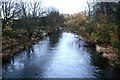
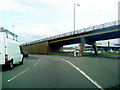
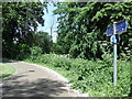
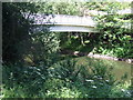
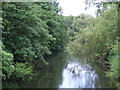
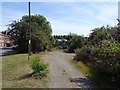
Chaddesden West Ward occupies a distinct residential zone within the wider Chaddesden area of Derby. This unitary authority ward covers an area of 3.4 km² and holds a population of approximately 1,545 residents. Historically known as Cedesene or Cedesdene, the location was recorded in the Domesday Book of 1086 as a manor held by Henry de Ferrers. It now lies about 2.5 miles east of Derby city centre following formal boundary extensions in 1928, 1934, and 1968. The landscape retains significant historical depth, featuring St Mary the Virgin Church, a Grade 1 listed building from the 14th century that once served as the village focal point. Nearby, Chaddesden Park offers 60 acres of public open space, opened around 1936 on the former site of the Wilmot estate. Residents can still visit the paddling pool located where old fish ponds once stood. The area has evolved from its origins as a separate village into an integrated part of Derby, maintaining a connection to its past while accommodating modern living needs.

Area Type
District Borough Unitary Ward
Area Size
3.4 km²
Population
Not available
Population Density
Not available

Demographics

The community profile of Chaddesden West Ward reflects an area with a notably mature population. Census data indicates a median age of 70 years, placing it amongst the older demographics in the region. The most common age grouping aligns with the broader total age distribution, which is not separately specified. House ownership rates stand at 51%, indicating that just over half of the occupied dwellings are owned outright or with a mortgage by the residents. The remaining properties are likely rented, though specific rental versus social housing breakdowns are not detailed. Accommodation types across the ward follow general patterns for the area, and the prevalent ethnic group represents the total population distribution without a distinct minority emphasis in the available data. Religious affiliation also mirrors the total demographic composition. You will find a settled community where the majority of households belong to the older generation. This age profile suggests a neighbourhood geared towards retirement and long-term residence rather than a transient student or young professional population.

Household Size

total
most common

Accommodation Type

total
most common

Tenure

51
majority

Ethnic Group

total
most common

Religion

total
most common

Household Composition

total
most common

Age

70
median
Age: Total
most common

Household Deprivation

N/A
with no deprivation

NS-SEC

19
in Lower managerial occupations

Explore more demographic insights in this area

Go to Demographics tab

Planning

Planning Constraints

  • Flood Risk
    Premium
  • Ramsar Wetland Sites
    Premium
  • Area of Outstanding Natural Beauty
    Premium
  • Protected Nature Reserve
    Premium
  • Protected Woodland
    Premium
  • Crime Risk
    Premium

Explore more planning insights in this area

Open Planning map

Frequently Asked Questions

What does the age profile tell me about who lives in Chaddesden West Ward?
The ward has a significantly older demographic compared to the national average. The median age is 70 years, meaning half the population is older than this mark. This profile indicates a community suited for retirement living rather than families with young children or young professionals moving in for career progression. The 51% home ownership rate further suggests a settled population choosing to remain long-term.
How reliable is the internet connection in the area?
Digital connectivity is excellent for residents of Chaddesden West Ward. The broadband quality score is 100 out of 100, representing the highest possible quality of fixed broadband service in the region. If you work from home or rely heavily on high-speed internet for daily activities, you can expect to receive top-tier speeds without interruption across the entire ward.
Are there significant flood risks I should worry about when buying?
Yes, flood risk is a critical consideration for this location. The ward has a high flood risk coverage with an assessment score of 45.14, where a lower score indicates less risk. Potential buyers must check specific property locations regarding flood history and planning constraints, as this factor covers a substantial part of the 3.4 km² area.
Is the area considered safe from crime?
Crime rates in Chaddesden West Ward are around the national average. The safety assessment assigns a warning level with a score of 46 out of 100, classifying the crime risk as medium. Residents should adopt standard security precautions such as locking doors and securing windows, but there is no indication of a high-crime environment disproportionate to other UK towns.

We use cookies to provide you with the best experience. By continuing, you agree to our Cookie Policy .