Area Overview for Caythorpe
Photos of Caythorpe


Area Information
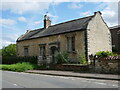
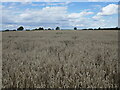
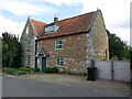
Caythorpe is a built-up area in England covering 57.9 hectares, offering a compact, well-defined living environment. With a median age of 70, the population reflects a mature demographic, suggesting a community of long-term residents. The area’s character is defined by its proximity to Ancaster Railway Station and two nearby airports, RAF Barkston Heath and RAF Cranwell, which provide easy access to regional travel. Daily life here is shaped by a balance of local amenities and connectivity. The area’s 75% home ownership rate indicates a stable housing market, with residents likely prioritising permanence over rental flexibility. While the data does not specify the exact types of homes, the built-up nature of the area suggests a mix of residential properties. For those seeking a quiet, established community with practical access to transport, Caythorpe offers a straightforward, no-frills lifestyle. Its small size means residents are close to essential services, though the lack of detailed information on local parks or leisure facilities leaves room for further exploration.
- Area Type
- Built Up Area 250
- Area Size
- 57.9 hectares
- Population
- Not available
- Population Density
- Not available
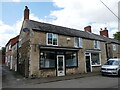
Caythorpe’s lifestyle is shaped by its proximity to retail, transport, and military facilities. The area has three notable retail outlets, including Spar and Co-op Ancaster, offering everyday shopping needs. Ancaster Railway Station provides access to regional destinations, while the presence of RAF Barkston Heath and RAF Cranwell introduces a unique character to the area, with potential for related employment opportunities. Although the data does not specify parks or leisure facilities, the compact nature of the area suggests that essential amenities are within practical reach. The combination of retail, transport, and military infrastructure creates a functional environment, though residents may need to travel further for more extensive leisure options. The availability of basic services supports a straightforward, practical lifestyle.
Amenities
Schools
Caythorpe has two primary schools in close proximity: The Caythorpe Primary School and Caythorpe Primary School, the latter of which holds a ‘good’ Ofsted rating. Both institutions cater to the needs of local families, providing early education within walking distance for many residents. The presence of two primary schools suggests a focus on foundational education, though the data does not mention secondary schools or further education facilities. For families prioritising primary education, the availability of two schools offers choice and convenience. The ‘good’ rating at one school indicates a standard of teaching and facilities that meet national benchmarks. However, the lack of information on secondary education means prospective residents should investigate further to understand full educational provision in the area.
| Rank | School | Type | Entry gender | Ages |
|---|
Explore more schools in this area
Go to Schools tabDemographics
The population of Caythorpe is predominantly aged 70, with the most common age range encompassing the total population. This suggests a community of older residents, many of whom may have lived in the area for decades. Home ownership is high at 75%, indicating a strong preference for long-term residency over rental properties. The accommodation types and household composition are not specified in the data, but the overall figures suggest a stable, settled population. The absence of detailed information on ethnic diversity or religious composition means the community’s cultural makeup remains undefined. For quality of life, the high home ownership rate and mature age profile imply a low turnover of residents, which can foster a sense of continuity. However, the lack of specific data on deprivation or income levels means it is unclear how economic factors influence daily living here.
Household Size
Accommodation Type
Tenure
Ethnic Group
Religion
Household Composition
Age
Household Deprivation
NS-SEC
Explore more demographic insights in this area
Go to Demographics tabPlanning
Planning Constraints
- Crime RiskPremium