Area Overview for Calver & Longstone Ward
Photos of Calver & Longstone Ward
Area Information
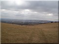
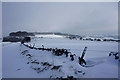
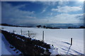
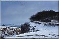
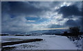
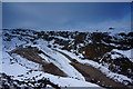
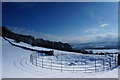
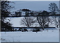
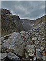
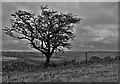
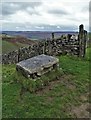
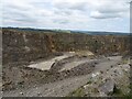
Living in Calver & Longstone Ward places you within a distinct 32.1 km² landscape defined by the Derbyshire Dales. This district council ward sits in the East Midlands at approximately 53.27°N, 1.62°W, encompassing the villages of Calver and Longstone within the wider Peak District terrain. You are situated in a setting identified by the Office of National Statistics code E05014595, offering a rural experience that is deeply rooted in the county map of Derbyshire. The area’s identity is tied closely to its physical location in the East Midlands region, where the rolling hills and historic paths are central to daily life. Your daily routine here involves navigating a landscape where the Monsal Trail provides a recreational walking and cycling route through the wider zone. While specific journey times to major cities or direct railway station details are not publicly quantified in local reports, the transport network is integrated with Derbyshire’s broader infrastructure. You are signing up for a slow-paced lifestyle where movement is often measured by miles walked or cycles rather than train timetables. The ward functions as a self-contained community within the Derbyshire Dales District Council area, where the local boundaries are clearly mapped for administrative purposes. Whether your interest stems from the picturesque scenery or the quiet village life, residing here means embracing a location where the natural environment dictates the rhythm of the day. The forward-looking and potentially useful implications of the data are clear: you are choosing a location where the physical geography is the primary feature of residence.
- Area Type
- District Borough Unitary Ward
- Area Size
- 32.1 km²
- Population
- Not available
- Population Density
- Not available
Demographics
The community profile of Calver & Longstone Ward is defined by a notably mature population. Your neighbours are largely seniors, with a median age of 70 years old. This demographic reality means that the typical resident is likely well into retirement age, and you are moving into an area where services and social circles cater primarily to older adults. The most common age grouping in the data is simply categorised as “Age: Total,” indicating that the entire population skew is towards this higher bracket rather than a balanced mix of families and young professionals. You are purchasing into a market with very high stability regarding tenure. Home ownership stands at 79 per cent, which is significantly higher than the national average. This figure suggests that the housing stock was largely purchased by long-term residents decades ago rather than acquired by owner-occupiers recently. Consequently, you are looking at established households where equity is already realised. When you consider the accommodation types and household composition, the data reflects a general trend without specifying distinct variants, implying a fairly uniform structure across the ward. The predominant ethnic group and religion categories are listed as total without further differentiation, pointing to a homogenous community that has remained largely unchanged over time. Living here means you will engage with a settled, older demographic where the social fabric is tightly woven around the local villages. There is no evidence of significant demographic churn, and the area retains its traditional character without the influx of younger, mobile workers often found in urban centres.
Household Size
Accommodation Type
Tenure
Ethnic Group
Religion
Household Composition
Age
Household Deprivation
NS-SEC
Explore more demographic insights in this area
Go to Demographics tabPlanning
Planning Constraints
- Flood RiskPremium
- Ramsar Wetland SitesPremium
- Area of Outstanding Natural BeautyPremium
- Protected Nature ReservePremium
- Protected WoodlandPremium
- Crime RiskPremium