Area Overview for Brigstock
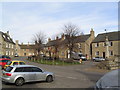
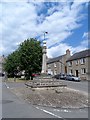
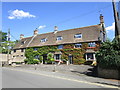
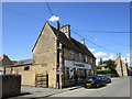
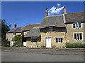
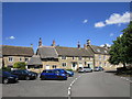
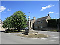
Photos of Brigstock


Area Information
Brigstock is a compact built-up area in England, spanning 53.2 hectares. Its character is shaped by a population with a median age of 70, suggesting a community skewed towards older residents. Daily life here is likely defined by a mix of local amenities and quiet surroundings, with the nearest railway station at Corby offering regional connectivity. The area’s proximity to retail hubs like Co-op Brigstock and Sainsburys Corby ensures basic shopping needs are met. While broadband quality is relatively poor, mobile coverage is strong, supporting digital lifestyles. The low crime risk, with a safety score of 74, adds to the appeal for those prioritising security. Brigstock’s appeal lies in its stability, practical amenities, and the presence of a well-regarded primary school, making it a viable choice for buyers seeking a low-maintenance, community-focused environment.
- Area Type
- Built Up Area 250
- Area Size
- 53.2 hectares
- Population
- Not available
- Population Density
- Not available
Brigstock’s lifestyle is anchored by nearby retail options, including Co-op Brigstock, Sainsburys Corby, and Tesco Little, ensuring daily essentials are within reach. The Corby Railway Station provides regional travel options, enhancing accessibility to larger towns and cities. While the area lacks detailed information on parks or leisure facilities, the availability of essential shops and transport links suggests a practical, no-frills approach to daily living. The combination of local retail and rail connectivity offers convenience for residents, though those seeking extensive leisure amenities may need to look beyond the immediate vicinity.
Amenities
Schools
The nearest school to Brigstock is the Brigstock Latham’s Church of England Primary School, which holds a good Ofsted rating. This institution serves the local community, providing education for younger residents. The absence of secondary schools or other educational institutions in the immediate vicinity means families with older children may need to travel to nearby areas for further schooling. However, the presence of a well-rated primary school is a significant asset for families prioritising quality early education. The single school option highlights the need for careful planning for families requiring a range of educational facilities.
| Rank | A + A* % | School | Type | Entry gender | Ages |
|---|---|---|---|---|---|
| 1 | N/A | Brigstock Latham's Church of England Primary School | primary | N/A | N/A |
Explore more schools in this area
Go to Schools tabDemographics
Brigstock’s population has a median age of 70, indicating a community predominantly composed of older adults. This demographic profile suggests a mature population, which may influence local services and social dynamics. Home ownership is high at 73%, reflecting a stable residential base with few renters. However, specific data on household types, accommodation preferences, or ethnic diversity is not available. The absence of detailed figures means broader conclusions about the community’s composition or deprivation levels cannot be drawn. What is clear is that the area’s older demographic may shape its character, with services and amenities tailored to this demographic’s needs.
Household Size
Accommodation Type
Tenure
Ethnic Group
Religion
Household Composition
Age
Household Deprivation
NS-SEC
Explore more demographic insights in this area
Go to Demographics tabPlanning
Planning Constraints
- Crime RiskLocked