Area Overview for Branston and Mere
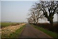
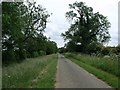
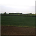
Photos of Branston and Mere


Area Information
Living in Branston and Mere offers a distinctive experience within a civil parish that spans 28.6 square kilometres. You will find a location defined by a very settled character, populated largely by an older generation. The median age here stands at 70, meaning families with young children are a minority compared to the established residents who have called this area home for decades. This demographic shift shapes the daily rhythm of life, creating an environment where tranquillity often takes precedence over the energy of a younger crowd. The sheer size of the parish provides ample space for your home, yet the community remains cohesive due to its mature population. When you consider purchasing homes in Branston and Mere, you are entering a market with a long history of stability. The area does not show signs of the rapid development or high-density housing that characterises parts of the wider East Midlands. Instead, it retains a village-like atmosphere where the landscape and the residents move in tandem. This makes the parish a quiet refuge, ideal for those seeking a slower pace of life without the isolation of complete rural anonymity. The area functions as a traditional parish where local institutions and neighbours matter more than transactional convenience. The community within Branston and Mere is overwhelmingly mature, with a median age of 70 years. This figure underscores a settlement that has been a retirement destination or a retirement phase for many decades. You will find that the population is not spread evenly across age groups; instead, the residents skew heavily towards those in their later years. This demographic reality influences local services and social infrastructure, though specific details on household composition and predominant ethnic groups are not provided in the current data. Home ownership is the dominant housing tenure in the area. Three quarters, or 75%, of residents own their homes outright or with a mortgage. This high level of ownership contributes to the stability you see in neighbourhood interactions and property values. Since most families own their residences, the area likely hosts fewer short-term rental tenants than urban centres. The high ownership rate suggests a long-term commitment to the locality, which often translates into maintained gardens, stable neighbourly relations, and a lower turnover of residents. When you examine the property market in Branston and Mere, home ownership stands out as the defining characteristic. With 75% of the population owning their homes, the local estate is predominantly comprised of long-term residents rather than renters. This high ownership rate typically indicates a stock of older, well-maintained properties where builders and family owners have cared for their assets over many years. You are unlikely to encounter a speculative buy-to-let market here. Accommodation types reflect the historical development of the parish. The housing likely consists of traditional brick villas, semi-detached homes, and terraced cottages common to many established civil parishes in England. The fact that three out of every four residents own their homes suggests that newcomers face a competitive market if they wish to join this community. Prices may reflect the desirability of owner-occupier stability and the lower density of high-rise flats or student accommodation. Digital connectivity in Branston and Mere supports modern working lifestyles while the area remains relatively quiet. Fixed broadband quality scores highly, achieving a rating of 93 out of 100. This excellent score means you can expect fast, reliable speeds for video calls, large file transfers, and streaming without noticeable lag. For anyone working from home, this infrastructure provides the foundation for a seamless digital routine. Mobile coverage also performs well across the parish. The mobile network quality score reaches 80 out of 100, indicating strong signal reception for most residents. You should experience consistent service for smartphones and tablets whether you are walking through streets or enjoying the outdoors. This level of connectivity ensures that staying connected is easy, even if physical transport links to major motorways or rail hubs are not detailed in the current data. The combination of superior fixed and mobile networks makes Branston and Mere suitable for remote workers who require constant internet access. Safety in Branston and Mere presents a mixed picture of environmental risks and crime levels. The area has a low crime risk, reflected in a safety score of 83 out of 100. This indicates that the parish has below-average crime rates compared to other locations. You can expect fewer incidents of theft, vandalism, or anti-social behaviour than in many comparable regions. The quiet nature of the mature community likely supports this lower crime rate, as neighbours often know one another and look out for each other. However, there is a critical environmental consideration you must address. Flood risk coverage in the area is rated as critical, with a score of 31.44 out of 100. A low score on this scale indicates a high probability of flooding affecting parts of the parish. You may need to check specific property histories for flood warnings before buying. This risk exists alongside planning constraints; the parish passes assessments for Ramsar wetland sites, Areas of Outstanding Natural Beauty, and protected nature reserves. These planning designations mean that development in the area is strictly controlled to protect the natural environment, limiting expansion into the landscape. Who typically lives in Branston and Mere?Residents in Branston and Mere are predominantly older adults, with a median age of 70. The community is stabilised by a high home ownership rate of 75%, indicating that most people own their properties rather than rent them. This demographic profile suggests a quiet, established neighbourhood far removed from urban centres.Is the internet fast enough for working from home in Branston and Mere?Yes, the area offers excellent digital connectivity. Fixed broadband scores 93 out of 100, providing highly reliable speeds for remote work. Mobile coverage is also strong with a quality score of 80 out of 100, ensuring consistent network access for all residents.How safe is Branston and Mere for families?Crime risk in Branston and Mere is low, with a safety score of 83 out of 100. The area records below-average crime rates, making it a secure environment. However, prospective buyers must be aware of a critical flood risk score of 31.44, which indicates significant potential for flooding in certain parts of the parish.
- Area Type
- Parish
- Area Size
- 28.6 km²
- Population
- Not available
- Population Density
- Not available
Demographics
The community within Branston and Mere is overwhelmingly mature, with a median age of 70 years. This figure underscores a settlement that has been a retirement destination or a retirement phase for many decades. You will find that the population is not spread evenly across age groups; instead, the residents skew heavily towards those in their later years. This demographic reality influences local services and social infrastructure, though specific details on household composition and predominant ethnic groups are not provided in the current data. Home ownership is the dominant housing tenure in the area. Three quarters, or 75%, of residents own their homes outright or with a mortgage. This high level of ownership contributes to the stability you see in neighbourhood interactions and property values. Since most families own their residences, the area likely hosts fewer short-term rental tenants than urban centres. The high ownership rate suggests a long-term commitment to the locality, which often translates into maintained gardens, stable neighbourly relations, and a lower turnover of residents. When you examine the property market in Branston and Mere, home ownership stands out as the defining characteristic. With 75% of the population owning their homes, the local estate is predominantly comprised of long-term residents rather than renters. This high ownership rate typically indicates a stock of older, well-maintained properties where builders and family owners have cared for their assets over many years. You are unlikely to encounter a speculative buy-to-let market here. Accommodation types reflect the historical development of the parish. The housing likely consists of traditional brick villas, semi-detached homes, and terraced cottages common to many established civil parishes in England. The fact that three out of every four residents own their homes suggests that newcomers face a competitive market if they wish to join this community. Prices may reflect the desirability of owner-occupier stability and the lower density of high-rise flats or student accommodation. Digital connectivity in Branston and Mere supports modern working lifestyles while the area remains relatively quiet. Fixed broadband quality scores highly, achieving a rating of 93 out of 100. This excellent score means you can expect fast, reliable speeds for video calls, large file transfers, and streaming without noticeable lag. For anyone working from home, this infrastructure provides the foundation for a seamless digital routine. Mobile coverage also performs well across the parish. The mobile network quality score reaches 80 out of 100, indicating strong signal reception for most residents. You should experience consistent service for smartphones and tablets whether you are walking through streets or enjoying the outdoors. This level of connectivity ensures that staying connected is easy, even if physical transport links to major motorways or rail hubs are not detailed in the current data. The combination of superior fixed and mobile networks makes Branston and Mere suitable for remote workers who require constant internet access. Safety in Branston and Mere presents a mixed picture of environmental risks and crime levels. The area has a low crime risk, reflected in a safety score of 83 out of 100. This indicates that the parish has below-average crime rates compared to other locations. You can expect fewer incidents of theft, vandalism, or anti-social behaviour than in many comparable regions. The quiet nature of the mature community likely supports this lower crime rate, as neighbours often know one another and look out for each other. However, there is a critical environmental consideration you must address. Flood risk coverage in the area is rated as critical, with a score of 31.44 out of 100. A low score on this scale indicates a high probability of flooding affecting parts of the parish. You may need to check specific property histories for flood warnings before buying. This risk exists alongside planning constraints; the parish passes assessments for Ramsar wetland sites, Areas of Outstanding Natural Beauty, and protected nature reserves. These planning designations mean that development in the area is strictly controlled to protect the natural environment, limiting expansion into the landscape. Who typically lives in Branston and Mere?Residents in Branston and Mere are predominantly older adults, with a median age of 70. The community is stabilised by a high home ownership rate of 75%, indicating that most people own their properties rather than rent them. This demographic profile suggests a quiet, established neighbourhood far removed from urban centres.Is the internet fast enough for working from home in Branston and Mere?Yes, the area offers excellent digital connectivity. Fixed broadband scores 93 out of 100, providing highly reliable speeds for remote work. Mobile coverage is also strong with a quality score of 80 out of 100, ensuring consistent network access for all residents.How safe is Branston and Mere for families?Crime risk in Branston and Mere is low, with a safety score of 83 out of 100. The area records below-average crime rates, making it a secure environment. However, prospective buyers must be aware of a critical flood risk score of 31.44, which indicates significant potential for flooding in certain parts of the parish.
Household Size
Accommodation Type
Tenure
Ethnic Group
Religion
Household Composition
Age
Household Deprivation
NS-SEC
Explore more demographic insights in this area
Go to Demographics tabPlanning
Planning Constraints
- Flood RiskPremium
- Ramsar Wetland SitesPremium
- Area of Outstanding Natural BeautyPremium
- Protected Nature ReservePremium
- Protected WoodlandPremium
- Crime RiskPremium