Area Overview for Bramcote Ward
Photos of Bramcote Ward
Area Information
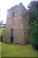
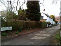
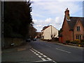
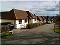
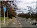
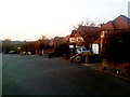
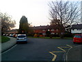
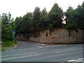
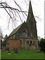
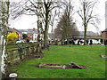
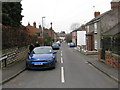
Living in Bramcote Ward offers a quiet retreat defined by its compact size and deep historical roots. This suburban village sits within the Broxtowe district of Nottinghamshire, covering just 4.6 square kilometres on the northern slopes of the Trent valley. Although first recorded as Bruncote in the Domesday Book of 1086, the area remains a recognised ward today with a population of 1300 people. The density here stands at 281 people per square kilometre, ensuring a predominantly rural character rather than the urban congestion found in nearby Nottingham. Daily life revolves around local landmarks such as the Grade II listed tower of the old Bramcote Church and Bramcote Manor House, a property built around 1600. The Turnpiked Derby Road, known as the A52, runs through the ward, providing a direct link between Stapleford and Beeston. Residents enjoyed several centuries of road development, with tolls finally removed in the 1870s. Today, the village retains its identity as a former civil parish, separate from the larger municipal borough structure. You can find Bramcote Ward situated comfortably between Stapleford and Beeston, maintaining its status as one of Nottinghamshire's hidden historical gems.
- Area Type
- District Borough Unitary Ward
- Area Size
- 4.6 km²
- Population
- 1300
- Population Density
- 281 people/km²
Demographics
The community in Bramcote Ward is exceptionally mature compared to the national average. The median age for residents is 70, indicating that the ward caters almost exclusively to older adults and retirees. There is no specific data provided to break down the age range further, but the high median age suggests a village where life slows down after work hours. With a population of 1300 spread across 4.6 square kilometres, the social fabric is tightly knit among generations that have likely lived in the area for decades. Home ownership is the dominant feature of neighbourhood life, with 84% of properties owned by their occupants. This high rate of ownership implies stability and a lack of transient rental populations. The demographic data does not specify predominant ethnic groups, religious affiliations, or detailed household compositions, suggesting a traditional English village profile. For those considering homes in Bramcote Ward, the environment feels tailored to those seeking a settled, family-owned property market rather than a dynamic student or young professional hub. The absence of young demographics aligns with the 70-year-old median age, creating a calm atmosphere suitable for quiet retirement living.
Household Size
Accommodation Type
Tenure
Ethnic Group
Religion
Household Composition
Age
Household Deprivation
NS-SEC
Explore more demographic insights in this area
Go to Demographics tabPlanning
Planning Constraints
- Flood RiskPremium
- Ramsar Wetland SitesPremium
- Area of Outstanding Natural BeautyPremium
- Protected Nature ReservePremium
- Protected WoodlandPremium
- Crime RiskPremium