Area Overview for Billing and Rectory Farm Ward
Photos of Billing and Rectory Farm Ward


Area Information
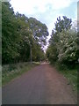
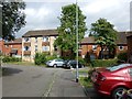
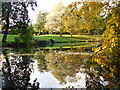
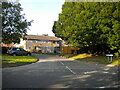
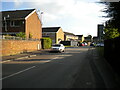
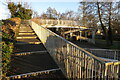
Billing and Rectory Farm Ward is a 3.4 km² district borough unitary ward situated in Northamptonshire within the East Midlands region. This small yet significant area encapsulates a distinct transition from historical rural villages to modern suburban life. The ward encompasses parts of Great Billing and Little Billing, two settlements that were once separate entities before amalgamating to form the civic parish of Billing in 1935. You are looking at a community of 1,684 residents, a population density that totals 491 people per square kilometre. Following the 1970s expansion by the Northampton Development Corporation, new residential estates such as Bellinge and Ecton Brook were constructed. These developments effectively joined the two historic villages together and brought them within the town boundary of Northampton. The history here is deep, with St. Andrews Church standing as a 12th Century heritage landmark dating back to the medieval period. Residents enjoy access to Billing Leys, an open space donated in perpetuity to the parish council in 1987. Living in Billing and Rectory Farm Ward offers proximity to meaningful local history alongside the convenience of the wider town of Northampton. Recent infrastructure work includes the restoration of the original ha-ha around Billing Hall, a project supported by the Heritage Lottery Fund beginning in 2012.
- Area Type
- District Borough Unitary Ward
- Area Size
- 3.4 km²
- Population
- 1684
- Population Density
- 491 people/km²
Demographics
The community profile within Billing and Rectory Farm Ward reveals a very成熟 population. The median age for residents is 70 years, positioning the most common age range at Age: Total. This indicates a neighbourhood where older generations dominate the local landscape. A significant majority of households, at 60 percent, consist of owner-occupiers rather than tenants. This high level of home ownership suggests stability and a long-term commitment to the ward by its permanent residents. The demographic data does not specify predominant ethnic groups or religious affiliations, leaving the precise cultural composition undefined in the current records. However, the shared characteristic is a mature population structure where age is the primary defining statistic. When considering the skill mix or employment status of the population, the available figures point toward a retired or semi-retired demographic. For anyone interested in the social fabric of Billing and Rectory Farm Ward, the data clearly highlights an area where older generations form the core of the community. This profile often correlates with quieter streets and a slower pace of life compared to more youthful urbanSub-areas.
Household Size
Accommodation Type
Tenure
Ethnic Group
Religion
Household Composition
Age
Household Deprivation
NS-SEC
Explore more demographic insights in this area
Go to Demographics tabPlanning
Planning Constraints
- Flood RiskPremium
- Ramsar Wetland SitesPremium
- Area of Outstanding Natural BeautyPremium
- Protected Nature ReservePremium
- Protected WoodlandPremium
- Crime RiskPremium