Area Overview for Belper
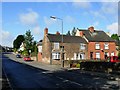
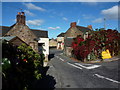
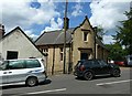
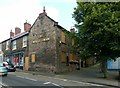
Photos of Belper


Area Information
Living in Belper offers a distinct blend of quiet village life and accessible town sprawl. This built-up area covers 5.1 square kilometres and spans the boundary between Derbyshire and Staffordshire. You will find a population of 1,682 residents spread across this relatively compact space, resulting in a density of 329 people per square kilometre. The area feels intimate yet connected, situated near the River Derwent and the historic Potteries. Its location places you just a short distance from the M1 motorway, linking the Dales to major industrial centres like Derby and Nottingham. Daily life here revolves around a slow pace, characterised by Georgian architecture and leafy residential streets. Despite its small size, Belper functions as a self-contained community with its own railway station and local amenities. You do not have to travel far for essentials, yet you retain easy access to larger towns through excellent transport links. This balance makes the area particularly appealing to those who value a settled environment without isolation. The town centre retains a historic charm while modern infrastructure supports contemporary living standards.
- Area Type
- Built Up Area 250
- Area Size
- 5.1 km²
- Population
- 1682
- Population Density
- 329 people/km²
Your daily life in Belper benefits from a convenient array of amenities located within practical reach. Shopping needs are met by five nearby retail locations, including Co-op Whitemoor, Tesco Alton, and Co-op Belper. These superstores provide fresh food, household goods, and daily essentials without the need to drive into larger cities. Five railway stations serve the area, including Belper Railway Station, Ambergate Railway Station, and Duffield Railway Station. Direct train connections to Idridgehay and Wirksworth offer easy weekend escapes or commuting options into Derby. This rail network integrates you with the wider Midlands region without requiring a car for every trip. You can reach these key destinations quickly, balancing town convenience with rural tranquillity. The presence of multiple shopping and transport hubs ensures you never feel cut off from the world.
Amenities
Schools
Families living in Belper have access to a cluster of local schools situated just within the neighbourhood boundaries. Three primary schools hold a 'Good' Ofsted rating, providing parents with three solid options for early education. Long Row Primary School, Herbert Strutt Primary School, and St John's CofE Primary School and Nursery all carry the 'Good' designation, assuring quality teaching standards. Pottertery Primary School is also nearby with a 'Satisfactory' rating, offering another educational choice within walking distance. St Elizabeth's Catholic Primary School is another option available to the community. This mix allows you to choose between community-led faith schools and state-funded primary institutions based on your specific values. The concentration of 'Good' rated schools suggests a commitment to education in the catchment area. You will find that the schools listed serve the local population directly, reducing the need to commute your children to larger towns. The variety of providers means you can find a school that matches your child's needs without travelling far from your home.
| Rank | School | Type | Entry gender | Ages |
|---|
Explore more schools in this area
Go to Schools tabDemographics
The community in Belper possesses a unique demographic profile that shapes the daily rhythm of the neighbourhood. The median age stands at 70 years, indicating a very mature population where retirees and older adults form the core demographic. While the data shows the most common age range as "Age: Total," the high median age suggests few young families compared to the established residents you might find elsewhere. Home ownership is the dominant form of tenure, with 78% of homes fully owned by their occupants. This high rate of ownership typically translates to stable neighbourhoods where long-term residents have invested in their properties. Household composition and accommodation type figures are available in the broader dataset, though specific breakdowns are not detailed. The area lacks significant ethnic diversity statistics in the provided records, reflecting a predominantly settled, traditional demographic. This homogeneity creates a predictable and settled atmosphere. You are less likely to encounter transient renting populations here. The low deprivation levels associated with such a stable ownership base generally contribute to a high quality of life. Residents enjoy the benefits of a quiet, low-stress environment without the volatility often found in commuter belts.