Crime & Safety
Crime in NR2 1AS is well above the national average. Safety score 1 out of 100, where higher is safer. Check the breakdown below.
Very high crime
This is not a sales listing. Propbar data is compiled for informational purposes.
Walkability
50 / 100
Somewhat walkable
Transit
39 / 100
Limited transit
Closest essential
Tesco London
2 min walk
Closest transport
Norwich Railway Station
13 min walk
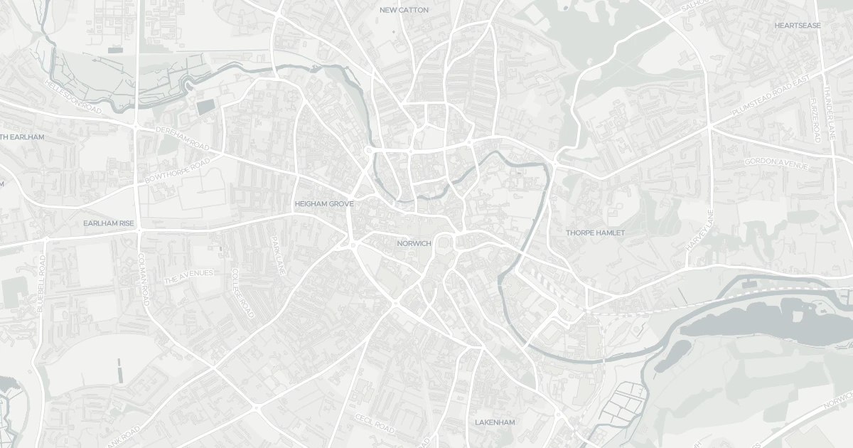
See nearby essentials and transport links overlaid on the property's location.
5 essentials within a 15-min walk. Closest nearby: 5 grocers.
Supermarket · Format varies by store — check before a big shop · 0.09 km
Supermarket · Format varies by store — check before a big shop · 0.43 km
Independent grocer · Local independent, top-up shop & specialty items · 0.43 km
Supermarket · Format varies by store — check before a big shop · 0.51 km
Supermarket · Format varies by store — check before a big shop · 0.51 km
4 rail stations nearby. Check direct routes & frequency for your journeys.
Railway station · National Rail — check destinations & direct services · 0.90 km
Railway station · National Rail — check destinations & direct services · 8.30 km
Railway station · National Rail — check destinations & direct services · 8.44 km
Railway station · National Rail — check destinations & direct services · 9.89 km
1 airport nearby. For long-distance travel — check destinations & routes.
Airport · Flights & long-distance travel — check destinations · 4.56 km
Scores blend proximity and density of nearby essentials and transport links. Closer, with more options, scores higher.
A one-bedroom terraced house at 9 Parsonage Square in Norfolk (NR2 1AS). It offers one bathroom and around 52 m² of floor space. The property holds an EPC rating of D and dates from before 1899. Land Registry records a sale at £80,000 in September 2009. Nearby shops include Tesco London, Tesco Norwich, M&S Norwich and Sainsburys Norwich St, the closest about 90 m away. The nearest stations are Norwich Railway Station, Salhouse Railway Station and Brundall Gardens Railway Station, around 904 m away. The Environment Agency rates this address at low risk of flooding.
Last Asking Price
£190,000
Last on market 5 years ago
Propbar's Valuation Beta
£XXX
Range £XXX – £XXX
Price position
Price per sq ft
£XXX
Based on 560 ft²
Last Sold
£175,000
Sold June 2021 · +£15,000 (+9%)
Market Timeline
—
Not currently listed
Times Listed
2 listings
Re-listed
Last Asking Rent
£875 pcm
£10,500 per year · Last on market 2 years ago
Propbar's Valuation Beta
£XXX pcm
Range £XXX – £XXX pcm
Rent position
Gross Yield
X.X%
Annual return rate
Last Let
£875 pcm
Listed November 2024
Days on Market
—
Not currently listed
Times Listed
2 listings
Re-listed
1 of 12sections reviewed
Crime in NR2 1AS is well above the national average. Safety score 1 out of 100, where higher is safer. Check the breakdown below.
Built before 1899.
Freehold confirmed by HM Land Registry. Unlock to reveal owner, charges and restrictions.
This property has 2 re-listingson record.
Sold prices, sales volumes and market pace for NR2 over the last 24 months.
Nothing on record for this property. See what's being applied for and built around it.
Rivers & sea, surface water and the 2080 climate outlook for this address.
What band D means for your bills, rental rules and upgrade headroom.
This address sits inside a council-declared air quality zone. What that means for living here is below.
Where NR2 1AS sits on the national prosperity ladder, and what drives it.
Admission chances, ratings and catchment status for 39 schools nearby.
5 essentials within 15 min walk · 5 transport links nearby
We use cookies to provide you with the best experience. By continuing, you agree to our Cookie Policy .