Crime & Safety
Crime in NR30 2DX is well above the national average. Safety score 1 out of 100, where higher is safer. Check the breakdown below.
Very high crime
This is not a sales listing. Propbar data is compiled for informational purposes.
Rivers & sea
Low
Depth not modelled
Surface water
Low
Low hazard rating
Climate 2080
Stable
Low projected for 2080
Flood defences
79 nearby
Nearest 450m away
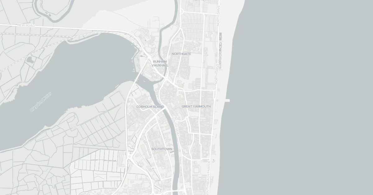
Use the interactive map to see how flood layers sit relative to the property.
Both modelled flood sources for this property are low or very low. No action expected.
About a 1-in-1,000 chance each year.
Heavy rain may cause minor pooling in low-lying areas. Flows up to 0 m/s. Low hazard rating.
This property sits in Flood Zone 3 — the highest-probability planning zone. Developing or extending here normally needs a Flood Risk Assessment and must pass the planning sequential test.
A high-probability planning zone. FRA and sequential test required, and an exception test may apply for more-vulnerable uses.
Flood defences sit nearby. They reduce but never remove flood risk, and may not protect this specific property.
Flood defences sit nearby. They reduce but never remove flood risk, and may not protect this specific property.
On River Yare, maintained by Environment Agency, rated to a 1 in 1000-year event, good condition.
Climate models project flood risk here will stay broadly stable through 2080.
Flood risk here is projected to stay broadly stable through the 2080s under current climate models.
At this flood-risk level, standard home insurance typically covers flooding without difficulty.
At this flood-risk level, standard home insurance typically covers flooding without difficulty.
A government-backed scheme that helps keep flood insurance affordable for eligible homes built before 2009.
General guidance based on the modelled flood-risk level — not an insurance quote or advice.
Source: Environment Agency · National Flood Risk Assessment (NaFRA 2), via Vepler Flood . Check on GOV.UK
A detached house at 74 North Market Road, NR30 2DX. It is currently sold subject to contract. It offers around 62 m² of floor space. The property holds an EPC rating of E and dates from 1900–1929. Nearby shops include Iceland Great, Sainsburys Great, Aldi Great and Farmfoods Cobholm, the closest about 86 m away. The nearest stations are Great Yarmouth Railway Station and Berney Arms Railway Station, around 685 m away. The Environment Agency rates this address at low risk of flooding.
Sale Agreed
£20,000
Last on market 1 year ago
Propbar's Valuation Beta
£XXX
Range £XXX – £XXX
Price position
Price per sq ft
£XXX
Based on 667 ft²
Last Sold
—
No record
Market Timeline
Times Listed
1 listing
First listing
Last Asking Rent
—
Not currently listed
Propbar's Valuation Beta
£XXX pcm
Range £XXX – £XXX pcm
Rent position
Gross Yield
X.X%
Annual return rate
Last Let
—
No record
Days on Market
—
Not currently listed
Times Listed
—
No history
1 of 12sections reviewed
Crime in NR30 2DX is well above the national average. Safety score 1 out of 100, where higher is safer. Check the breakdown below.
Built 1900–1929.
Freehold confirmed by HM Land Registry. Unlock to reveal owner, charges and restrictions.
Listing history, price moves and time on market for this address.
Sold prices, sales volumes and market pace for NR30 over the last 24 months.
Nothing on record for this property. See what's being applied for and built around it.
Rivers & sea, surface water and the 2080 climate outlook for this address.
Meets the minimum EPC E required to let the property today.
Pollutant levels, the official index and health context for this address.
Where NR30 2DX sits on the national prosperity ladder, and what drives it.
Admission chances, ratings and catchment status for 27 schools nearby.
5 essentials within 15 min walk · 2 transport links nearby
We use cookies to provide you with the best experience. By continuing, you agree to our Cookie Policy .