Building
Building details available below.
Flat
This is not a sales listing. Propbar data is compiled for informational purposes.
Walkability
50 / 100
Somewhat walkable
Transit
55 / 100
Some transit
Closest essential
Spar
2 min walk
Closest transport
Hillfoot Railway Station
3 min walk
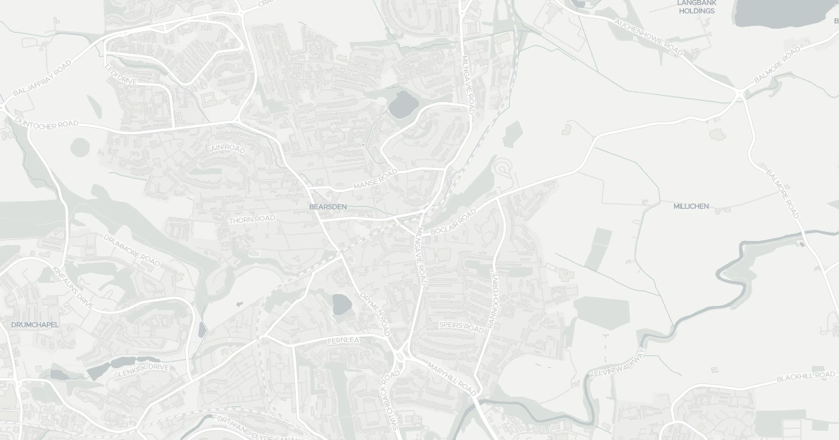
See nearby essentials and transport links overlaid on the property's location.
5 essentials within a 15-min walk. Closest nearby: 5 grocers.
Convenience store · Top-up shop, long opening hours, alcohol licence · 0.18 km
Supermarket · Big weekly shop, low prices, larger formats common · 0.32 km
Supermarket · Format varies by store — check before a big shop · 0.55 km
Convenience store · Top-up shop, ethical & local sourcing · 0.69 km
Independent grocer · Local independent, top-up shop & specialty items · 0.80 km
5 rail stations · 5 metro stops nearby. Check direct routes & frequency for your journeys.
Railway station · National Rail — check destinations & direct services · 0.10 km
Railway station · National Rail — check destinations & direct services · 0.71 km
Railway station · National Rail — check destinations & direct services · 1.84 km
Railway station · National Rail — check destinations & direct services · 2.47 km
Railway station · National Rail — check destinations & direct services · 2.77 km
Metro / Underground · Frequent urban transit, short-hop city travel · 5.24 km
Metro / Underground · Frequent urban transit, short-hop city travel · 5.58 km
Metro / Underground · Frequent urban transit, short-hop city travel · 5.68 km
Metro / Underground · Frequent urban transit, short-hop city travel · 6.30 km
Metro / Underground · Frequent urban transit, short-hop city travel · 6.42 km
1 airport · 5 ferry terminals nearby. For long-distance travel — check destinations & routes.
Airport · Flights & long-distance travel — check destinations · 9.40 km
Ferry terminal · Ferry services — check routes & destinations · 5.19 km
Ferry terminal · Ferry services — check routes & destinations · 5.40 km
Ferry terminal · Ferry services — check routes & destinations · 5.46 km
Ferry terminal · Ferry services — check routes & destinations · 5.98 km
Ferry terminal · Ferry services — check routes & destinations · 6.16 km
Scores blend proximity and density of nearby essentials and transport links. Closer, with more options, scores higher.
This flat is located at 139 Milngavie Road, G61 2QJ. It is currently sold subject to contract. Nearby shops include Spar, Asda Bearsden, Sainsburys Bearsden and Co-op Bearsden, the closest about 182 m away. The nearest stations are Hillfoot Railway Station, Bearsden Railway Station and Westerton Railway Station, around 99 m away.
Sale Agreed
£650,000
Last on market 8 months ago
Guide price: set to attract bidding, not a market valuation.
Propbar's Valuation Beta
£XXX
Range £XXX – £XXX
Price position
Price per sq ft
£XXX
Floor area required
Last Sold
—
No record
Market Timeline
Times Listed
1 listing
First listing
Last Asking Rent
—
Not currently listed
Propbar's Valuation Beta
£XXX pcm
Range £XXX – £XXX pcm
Rent position
Gross Yield
X.X%
Annual return rate
Last Let
—
No record
Days on Market
—
Not currently listed
Times Listed
—
No history
1 of 12sections reviewed
Building details available below.
We don't hold an HM Land Registry title on record for this address. This is common for leasehold flats, new builds and unregistered land.
Listing history, price moves and time on market for this address.
Sold prices, sales volumes and market pace for G61 over the last 24 months.
Nothing on record for this property. See what's being applied for and built around it.
Outside the modelled flood-risk coverage (Scotland and Wales publish their own assessments).
No Energy Performance Certificate data is on file for this property.
Crime data is only available for England and Wales, not Scotland.
Pollutant levels, the official index and health context for this address.
Prosperity data is not available for this property.
No school data is available for this property.
5 essentials within 15 min walk · 16 transport links nearby